Fun N/NE windswell event this period

Eastern Tasmania Surf Forecast by Craig Brokensha (issued Wednesday 5th December)
Best Days: Friday (southern corners late), Saturday, early Sunday
Recap
Tiny to flat waves yesterday and this morning, but we've got some fun swell on the cards for the coming period.
Today’s Forecaster Notes are brought to you by Rip Curl
This week and weekend (Nov 6 - 9)
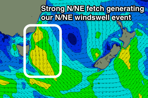
We're looking at a prolonged N/NE windswell episode, developing from tomorrow afternoon and persisting through until next week.
This will be a result of a strong and slow moving high sitting in the Tasman Sea, being squeezed on its western flank by a surface trough and low moving in from the west.
A strengthening and sustained fetch of N/NE winds extending from the southern NSW coast down to our region will be produced, developing tomorrow afternoon, strongest and best aligned tomorrow evening, but lingering Friday before weakening into Saturday.
 North-east facing beaches should build to 2ft+ later tomorrow with a gusty N'ly breeze, coming in at a larger 3ft+ on Friday, easing from a similar 3ft+ on Saturday morning, smaller and easing from 2ft+ Sunday.
Winds on Friday should be out of the NW most of the day but we're likely to see a SW change across the southern half of the coast late afternoon and into the evening.
This will favourable those north-east facing magnets later in the day.
Saturday morning will be clean with a light W/SW offshore and E'ly sea breezes, while Sunday looks poor with S/SE tending E'ly winds, best in southern corners early.
These S/SE winds will be linked to through moving in and across us, and with this we may see a small E'ly windswell for Monday morning, but we'll review this Friday.