Prolonged E/SE-SE swell event with improving winds

Eastern Tasmania Surf Forecast by Craig Brokensha (issued Friday 23rd November)
Best Days: Protected spots tomorrow and Sunday, Monday morning, Tuesday morning, Wednesday morning
Recap
The NE swell faded overnight Wednesday but some good E/SE swell filled in to replace it with favourable winds for protected spots.
Today's new building S/SE swell has come in way earlier and above expectations but this is due to the intense low that's currently sitting off our coast being positioned more east than forecast on Wednesday.
As are the dynamic nature of these systems, this has opened up our swell window to a fetch of gale-force S/SE winds last night and early this morning kicking up a large stormy swell, best suited to super protected breaks.
Today’s Forecaster Notes are brought to you by Rip Curl
This weekend and next week Nov 24 - 30)
Early this morning and up until late morning gale-force S/SE-SE winds were being generated through our south-eastern swell window, but the low has since started to drift slightly away resulting in winds easing and with this swell local windswell should of started to abate as well.
With the low weakening we'll see the local SE swell dropping through the day back from 4-5ft+ early with gusty S-S/SE winds. This will only favour protected spots which will be smaller.
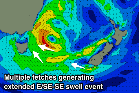 A re-intensification of SE winds projecting towards us through the day Saturday should produce a new pulse of E/SE and SE swell for Sunday coming in at 4-5ft and with slightly better S/SW winds early before shifting S/SE again.
Into early next week we'll see the swell slowly tailing away but this easing trend will be drawn out as a persistent fetch of E/SE-SE winds remain aimed towards us well into next week.
Conditions will continue to improve with a W/SW offshore Monday morning and clean 3-4ft waves, back to 3ft+ Tuesday and clean again through the morning.
Smaller surf and variable winds are expected on Wednesday, while another mid-latitude low moving in from the west mid-week will track much further north.
We should see some fun new E/NE swell off this low late week and more so next weekend, but we'll have another look at this on Monday. Have a great weekend!