Easing N/NE swell with building energy through early next week

Eastern Tasmania Surf Forecast by Craig Brokensha (issued Wednesday 14th November)
Best Days: North-east swell magnets tomorrow morning, open beaches Sunday and Monday mornings, next Wednesday
Recap
Fun levels of N/NE windswell yesterday with OK winds, cleaner and better today with a shallow S/SE change, favouring north-east swell magnets.
Today’s Forecaster Notes are brought to you by Rip Curl
This week and weekend (Nov 15 - 18)
The fetch linked to our current N/NE swell is currently moving away from us and with this we'll see the surf dropping from a smaller 2ft or so across swell magnets mixed in with a tiny weak S'ly windswell from an overnight change.
Winds will be best for those north-east swell magnets with an early S/SW breeze, tending more SE through the day.
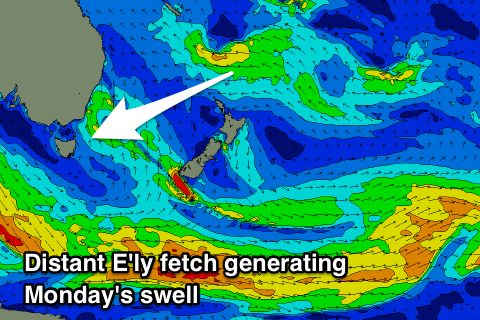 We've then got tiny surf due through Friday and the weekend (apart from a tiny E/SE swell Sunday), while a long-range and inconsistent E/NE swell is due to fill in Monday.
This will be generated by a deepening tropical depression above New Zealand tomorrow, with a fetch of strengthening E'ly winds being aimed through our north-eastern swell window.
The swell may be seen late Sunday but a peak is due Monday to an infrequent 2ft+ across open beaches. Winds will however be only favourable early and N/NW, quickly freshening from the NE with developing fetch down our coast.
We're looking at another fun N/NE windswell event through early next week as a good strong fetch of N/NE winds develop down out coast.
This swell event looks to come in around 2-3ft, with an offshore change on Wednesday, but we'll have another look at this Friday.