Small persistent N/NE swell next week

Eastern Tasmania Surf Forecast by Craig Brokensha (issued Friday 7th November)
Best Days: Tuesday northern corners, Wednesday, Thursday morning
Recap
A continuation of tiny to flat surf across the region with better options across the South Arm.
Today’s Forecaster Notes are brought to you by Rip Curl
This weekend and next week (Nov 10 - 16)
The surf will remain tiny to flat over the weekend, but our N/NE windswell event next week is looking a bit better.
There's a slim chance for a S'ly groundswell pulse Sunday afternoon from a strong polar low that's currently south-west of the state. The swell will be very acute in direction but we could see 1-2ft sets on the south magnets with NE sea breezes.
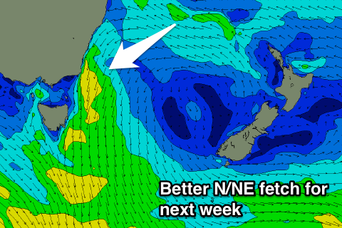 Into Monday, a trough approaching from the west through the Bight will squeeze a strong high in the Tasman Sea, with a strengthening fetch of N/NE winds developing down the coast into the afternoon.
A N/NE windswell should build overnight Monday and further Tuesday, with a peak expected through the day to 2-3ft at north-east facing beaches but with a N'ly wind. Early N/NW winds are likely, and later in the day a NW change should be seen, with a persistent NW breeze Wednesday as the swell eases from 2-3ft.
The easing trend will be slow as a persistent fetch of NE winds hang in our swell window through Wednesday, keeping small 2ft sets hitting the magnets on Thursday.
Longer term we may see a surface trough bringing an increase in S'ly windswell next weekend, but more on this Monday. Have a great weekend!