Small flukey south swell

Eastern Tasmania Surf Forecast by Craig Brokensha (issued Friday 2nd November)
Best Days: South magnets up the coast Sunday
Recap
A building N/NE windswell later yesterday with a peak this morning to a lumpy 2-3ft, but this ironed out through the day with a gusty W/NW offshore creating super fun waves.
Today’s Forecaster Notes are brought to you by Rip Curl
This weekend and next week (Nov 3 - 9)
Today's NE windswell will drop back rapidly overnight with tiny to flat conditions due tomorrow.
Into Sunday our flukey S'ly swell is still that but we should see some small sets across south magnets through the day.
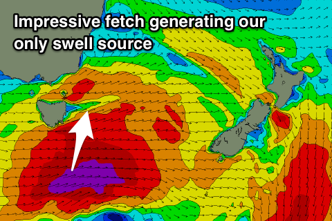 A vigorous cold front will push across the state tomorrow, with a fetch of severe-gale W/SW winds produced past our south-east corner into the afternoon.
A small refracted S'ly groundswell may be seen across the northern end of the coast as it spreads out radially into the Tasman Sea, with 2ft to maybe 3ft sets possible under an offshore W/NW wind.
After this the outlook is minimal with tiny surf due with generally favourable westerly winds as a strong node of the Long Wave Trough slowly pushes east from the Bight while weakening, directing zonal frontal activity across us.
Therefore check the South Arm forecast for more surfing options.
Check back here Monday for any change to the outlook next week. Have a great weekend!