Slight upgrade in south swell size and longevity

Eastern Tasmania Surf Forecast by Craig Brokensha (issued Friday 26th October)
Best Days: Sunday morning, Monday morning south swell magnets, later Friday
Recap
Tiny levels of background NE swell yesterday and today, but too small to surf.
Today’s Forecaster Notes are brought to you by Rip Curl
This week and weekend (Oct 27– Nov 2)
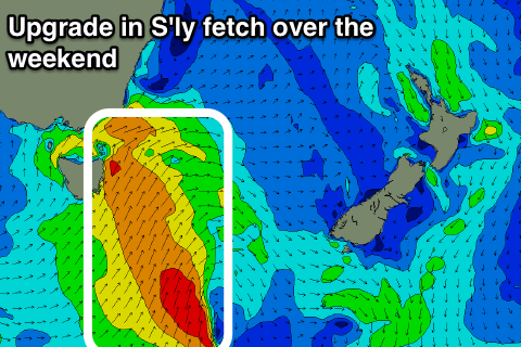
Tomorrow will start tiny, but a strong cold front pushing up past the coast will bring with it a strong S/SW wind and late increase in building S'ly windswell turning mid-period energy that's expected to peak overnight and ease slowly Sunday.
The strength of the front has been upgraded and with this we should see 3ft+ waves across across south facing beaches, smaller in more protected spots and winds are looking better with a morning W/SW breeze, onshore into the afternoon as the swell eases.
 Monday looks to still be 2ft+ out of the S/SE, easing through the day along with a variable tending E and then NE breeze.
The surf is then due to become tiny to flat until later in the week when a new N/NE windswell event is due to develop. There's the chance for a small S'ly signal to 1-2ft on Tuesday morning at south swell magnets, but it will likely be too west in nature.
The N/NE windswell event will be generated by a trough sliding in from the west, squeezing a small high in the Tasman Sea, generating a well aimed fetch of strengthening E/NE-NE winds towards us.
This should produce a rapid increase in size from later Thursday through Friday, reaching a fun 3ft+ across north-east facing beaches ahead of a late NW change. We'll have a closer look at this on Monday and confirm as the European model isn't as favourable regarding the expected size. Have a great weekend!