Fun Saturday, large south-east swell for next week

Eastern Tasmania Surf Forecast by Craig Brokensha (issued Friday 24th August)
Best Days: Saturday, Wednesday, Thursday and Friday
Recap
Super fun waves the last couple of days with good pulses of E/SE swell and favourable winds each morning.
This weekend and next week (Aug 25 - 31)
Today’s Forecaster Notes are brought to you by Rip Curl
The fetches generating our pulses of E/SE swell have since vanished from our swell window and with this we'll see the surf easing through tomorrow from 3ft at open beaches around dawn, smaller into the afternoon.
Some small S'ly groundswell will also be in the mix from a strong polar frontal system that formed south of the state last night.
While not ideally aligned and fast moving, we should still see 2-3ft sets across south magnets all day along with W/NW-NW winds.
 Sunday looks like a lay day with small 1-2ft leftovers, while our north-east swell from the fetch of NE winds off the southern NSW coast doesn't look great at all.
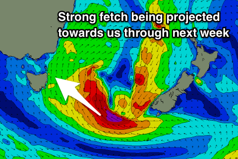
Instead though we'll see a polar front pushing up and past us Sunday evening and early Monday, forming into a strong low to our south-east.
This low is forecast to be much stronger and better aligned than the one seen this week and with this we're looking at large surf out of the south-east developing next week.
We'll see an initial small and poor increase in S/SE windswell on Monday afternoon from a broad fetch of strong S/SE winds developing east of us, but this will be more so Tuesday.
Of greater importance is the fetch around the southern flank of the low, generating gale to severe-gale E/SE-SE winds while retro-grading slightly to the west on Tuesday.
A large and powerful long-period SE groundswell should be generated for Wednesday, building to 8ft across open beaches with W/SW tending S'ly winds.
The swell will ease off Thursday with N/NW winds and then into the end of the week we could see a very strong cold-outbreak pushing east, bringing strong N'ly winds and a solid N/NE swell event.
More on this Monday though. Have a great weekend!