Great S'ly tending SE swell for the period

Eastern Tasmania Surf Forecast by Craig Brokensha (issued Friday 17th August)
Best Days: Sunday afternoon protected spots, Monday, Tuesday, Wednesday morning
Recap
Nothing of note yesterday, but our fun pulse of S'ly swell expected today came in on forecast with fun 2-3ft sets across south magnets.
This weekend and next week (Aug 18 - 24)
Today’s Forecaster Notes are brought to you by Rip Curl
Today's swell is due to ease back overnight leaving small to tiny 1-1.5ft waves across south swell magnets with offshore winds.
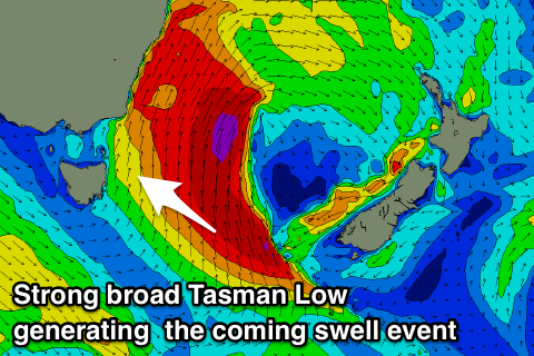
Moving into Sunday and the strong mid-latitude low is still forecast to move across us, projecting a fetch of strong to gale-force S/SE winds up past us.
 This will kick up a building and strengthening swell through Sunday, larger later with strong S/SW winds. There may be a few options later in the day in protected spots for desperate surfers.
We'll see a strong and deep Tasman Low form and with this stronger severe-gale S/SE are due to be aimed through our swell window Sunday evening and early Monday before continuing to drift away from us and out of our swell window.
We're expected to see a mix of easing S'ly swell and building S/SE groundswell on Monday with south facing beaches likely to see surf in the 6ft range most of the day, if not a touch bigger early and with good offshore W/SW tending variable winds.
This should produce good waves most of the day, while come Tuesday we'll see great easing levels of SE groundswell from the 4-5ft+ range with straight offshore W'ly winds.
With the low quickly pushing off to the east we'll see the swell easing rapidly, with Wednesday revealing small fading 3ft sets.
We'll have one final look at the backside of this swell event on Monday.
Longer term there's nothing significant on the cards for the rest of the week, so make the most of the coming swell event. Have a great weekend!