Fading S/SE swell with better developments late next week

Eastern Tasmania Surf Forecast by Craig Brokensha (issued Friday 9th February)
Best Days: Saturday morning south swell magnets, open beaches Sunday and Monday for keen surfers
Recap
Some decent N/NE windswell yesterday, cleaning up across southern corners through the day with a S'ly change.
Today we've got a mix of leftover N/NE windswell and inconsistent S/SE groundswell with morning variable winds from the S'th.
Today’s Forecaster Notes are brought to you by Rip Curl
This weekend and next week (Feb 10 - 16)
An inconsistent S/SE groundswell seen today across south magnets should ease through tomorrow from 2ft+ with N/NW winds.
Come Sunday there isn't due to be much swell at all on the cards, and a small E/NE swell due from a tropical low moving across New Zealand has been downgraded further.
The system is now due to sit above New Zealand, which will result in no size at all for us.
We may see inconsistent 1-2ft sets out of the east Sunday and Monday, fading through Tuesday.
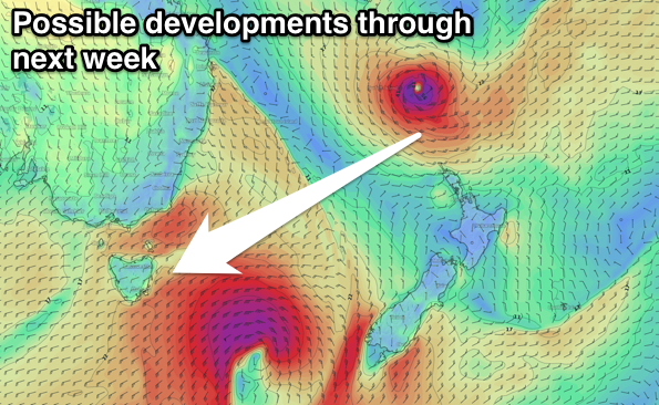 Looking further ahead to possible significant tropical developments which the models are firming on north and east of New Zealand.
We're due to see a strong upper blocking pattern support a stationary high pressure extending from the Tasman Sea, across New Zealand and well to the east.
A broad area of low pressure sitting north of the high with embedded lows and likely a tropical cyclone will produce a great fetch of E'ly trades which will be out of our swell window until mid-week.
We're likely to see one of the lows/cyclones retro-grading, with a fetch of strong to gale-force E/NE trades with stronger core winds around the low moving into our north-eastern swell window.
This is likely to generate a good sized E/NE groundswell for later next week/weekend, but check back here Monday for more on this.
Have a great weekend!