Fun N/NE windswell tomorrow, with a stronger S/SE groundswell Friday

Eastern Tasmania Surf Forecast by Craig Brokensha (issued Wednesday 7th February)
Best Days: Thursday afternoon at north-east magnets, Friday morning, Saturday morning, Sunday morning, Monday morning
Recap
A good S'ly groundswell yesterday with strong sets at south magnets, good again this morning and easing from 3ft at south magnets.
Today’s Forecaster Notes are brought to you by Rip Curl
This week and weekend (Feb 8 - 11)
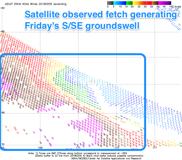
The S'ly swell will be all but gone tomorrow morning, but later in the day and more so Friday some new S/SE groundswell is due.
This has been generated by a fetch of gale to severe-gale S/SE winds on the polar shelf the last couple of days and should provide 3ft sets Friday across south magnets before easing 2ft to possibly 3ft Saturday morning.
 There'll be some small N/NE windswell also in the mix tomorrow to 3ft on the sets across north-east magnets with an early N/NW breeze shifting S'th into the afternoon as a weak trough moves off the coast.
Friday will then see W/SW offshores with the S/SE groundswell ahead of E'ly sea breezes.
Our new E/NE swell for Sunday/Monday has unfortunately been downgrades with a weak fetch of E/SE winds forming west of New Zealand North Island not expected to project as well towards us or be as strong.
What we'll see is some small E/NE swell filtering down Sunday, building to 2ft+ at open beaches and easing from a similar size Monday morning.
Winds look favourable and offshore each morning ahead of afternoon sea breezes.
Longer term there's nothing too major on the cards so make the most of the coming small swell pulses.