Easing S swell followed by a strong E/NE groundswell Friday

Eastern Tasmania Surf Forecast by Craig Brokensha (issued Wednesday 31st January)
Best Days: Thursday morning, Friday, Saturday morning, Monday morning, Tuesday
Recap
Average winds for most exposed breaks yesterday but favourable for southern corners with some fun NE sets still in the mix.
Today we've seen a low point in swell, but some new S'ly swell should be starting to kick across the coast a strong front pushing up past us.
Today’s Forecaster Notes are brought to you by Rip Curl
This week and weekend (Feb 1 - 4)
The change pushing up past our coast today isn't too amazing, with only a weak S'ly windswell due to build later today, easing rapidly tomorrow.
South magnets may see 3ft sets early, easing through the day with a W/SW tending E'ly breeze.
What we should also see in the mix is some inconsistent E/NE trade-swell from a persistent fetch of E'ly trades sitting on top the high that's been sitting in the Tasman Sea this week.
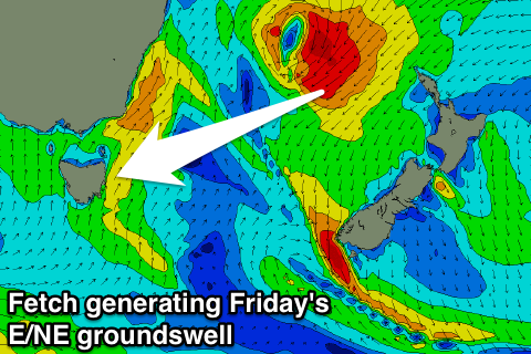 A slow increase from a small 2ft to 2-3ft later in the day is expected, ahead of our stronger E/NE groundswell Friday.
This groundswell has and is still being generated as tropical cyclone Fehi dips from the Coral Sea south, squeezing the high and generating a fetch of E/NE gales through our swell window.
Fehi will make an extra-tropical transition and drop quickly south through and out of our swell window across New Zealand tomorrow morning.
With this fast transition, the swell will ease quickly after it's peak, with Friday morning due to reveal strong 4-5ft sets across most open beaches, with possible larger bombs at swell magnets.
A morning W/SW wind will create great conditions, tending S/SE as the swell eases into the afternoon.
Come Saturday morning we're only looking at small easing 2-3ft sets with a morning W/SW breeze again, with small clean 1-2ft leftovers Sunday morning.
Into next week, a good slow moving polar front will aim a broad and elongated fetch of strong S/SW winds through our southern swell window, extending from the polar shelf up into the Tasman Sea Sunday and early Monday, generating some good S'ly swell for us Monday and Tuesday.
At this stage we're looking at 3ft+ waves across south magnets with a morning offshore Monday, better and from the NW Tuesday, but we'll confirm this Friday.
Comments
Hi Craig. I find it odd the daily forecast for Friday is only predicting a 1 metre NE swell and 3 foot swell when all else tells us we are expecting some solid NE swell