Good E/SE swell with a window of clean conditions

Eastern Tasmania Surf Forecast by Craig Brokensha (issued Monday 31st July)
Best Days: Thursday morning, later Friday, Saturday morning
Recap
Tiny waves over the weekend, similar today but there's some fun due across the region this week.
This week and weekend (Aug 1 - 6)
Our coming period will focus around a deepening Tasman Low to our east.
During tomorrow we'll see this low forming, with a broadening fetch of strong to gale-force SE winds due to develop in our eastern swell window.
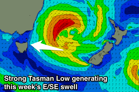 The fetch should reach a peak in intensity tomorrow afternoon before slowly weakening into Wednesday, further Thursday.
We should see building levels of E/SE swell through Wednesday, peaking Thursday morning.
Open beaches are expected to build to 3-4ft by dark Wednesday but with onshore SE winds, with Thursday seeing 3-4ft+ waves. Unfortunately another trough forming off the southern NSW coast will direct onshore E/NE winds into us most of Thursday, but the morning should see an early W'ly.
This onshore breeze will kick up some new E/NE swell for Friday, but our models are incorrectly combining the two different swells. We're likely to see 3ft waves Friday with onshore E/NE winds during the morning, tending NW later with an approaching front.
A final burst of E'ly gales out of Cook Strait Wednesday evening and Thursday looks to generate a small E'ly groundswell pulse for later Friday and Saturday morning, providing 2ft+ sets with offshore W/NW winds.
This swell will fade through the day with nothing major due for the rest of the weekend.
Longer term we may see some solid S'ly swell mid-next week, but more on this Wednesday.