Flat weekend with good E/SE swell next week

Eastern Tasmania Surf Forecast by Craig Brokensha (issued Friday 28th July)
Best Days: Wednesday and Thursday in protected spots, Friday
Recap
Great waves yesterday with a fun S'ly swell and offshore winds, but the swell has gone right off the boil overnight with nothing left into this morning.
This weekend and next week (Jul 29 – Aug 4)
With the S'ly swell dropping back so rapidly, tomorrow morning there isn't expected to be any size left at all across the coast.
 A quick burst of N'ly winds in our swell window this afternoon and evening will move away from us overnight, and with this there'll be no surfable N/NE swell left.
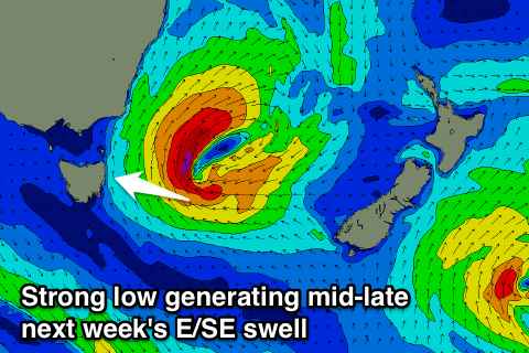
We then look forward to a deepening surface trough and low forming off the southern NSW coast early next week and drifting south off our coast.
As the low starts to develop a fetch of strong to gale-force E/SE winds will be generated in our eastern swell window, stalling to our east on Tuesday evening before weakening Wednesday.
We'll see a building E/SE swell late Tuesday but more so Wednesday, reaching 4ft late in the day and peaking Thursday morning to 4-5ft.
Winds look to be from the S/SW tending S/SE Wednesday and similar Thursday with offshore winds as the swell eases Friday. We'll take a closer look at this low Monday though when the models will be more aligned and certain on its strength and positioning. Have a great weekend!