Fun small S'ly swells this week

Eastern Tasmania Surf Forecast by Craig Brokensha (issued Monday 24th July)
Best Days: South magnets tomorrow morning, Thursday and Friday
Recap
Great waves Saturday with a strong E/SE groundswell and offshore winds, building from 3-4ft in the morning. The swell backed off overnight leaving less consistent 2ft waves across open beaches yesterday morning. Today there was nothing left at all with tiny waves and clear sunny skies.
This week and weekend (Jul 25 - 30)
A strong polar front is currently passing under the state, and we should see some new S/SW groundswell off this system for tomorrow morning.
It's not ideally aligned, and with this only south magnets will see any size. We may see 2-3ft sets through the morning, fading through the day, while all other spots will be tiny.
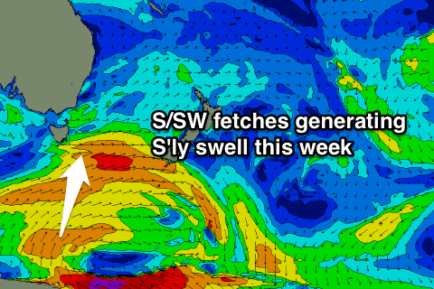 Some better aligned S/SW and then S'ly swell is due into Wednesday and Thursday afternoon respectively, produced by a stalling fetch of strong SW and S'ly winds to our south tomorrow and Wednesday.
The first pulse of S/SW swell is due to fill in Wednesday reaching 2ft+ across south facing beaches, but a small trough moving across us will bring a gusty S'ly change mid-morning and a building S'ly windswell with it.
Thursday looks the day to surf with a better aligned S'ly swell filling in and reaching 3ft across south facing beaches through the day along with a W/NW tending gusty N'ly wind.
These N'ly winds will kick up a tiny N/NE windswell Friday morning ahead of a W'ly change, but the S'ly swell will be better with easing 2-3ft sets across south facing locations.
Into the weekend we'll see the S'ly swell fade away with nothing significant for the coast until possibly next week in the form of N/NE windswell. More on this Wednesday though.