Great weekend of surf, smaller S'ly swells next week

Eastern Tasmania Surf Forecast by Craig Brokensha (issued Friday 21st July)
Best Days: Saturday, Sunday morning, south magnets through the day Monday, Tuesday morning, Thursday
Recap
Small to tiny amounts of S'ly swell with the odd peeler at south magnets. This morning a better SE swell has filled in from the developing Tasman Low to our east. Good clean 3ft waves out of the SE are breaking and there's more to come!
This weekend and next week (Jul 22 - 28)
Currently a very strong and broad Tasman Low is encompassing the entire Tasman Sea. A broad fetch of severe-gale SE winds are being aimed towards the mainland, and satellite observations have recorded some 50kt barbs (though not well aimed for us).
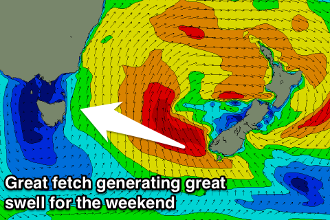 We'll see some great quality E/SE groundswell spreading out radially towards us, arriving through tomorrow and pulsing to a strong 3-5ft at open beaches (especially the northern half of the coast).
Conditions will be great with a gusty NW breeze all day, swinging more W'ly Sunday as the swell eases back quickly from 2-3ft.
As touched on last update, we'll be looking at S'ly swell energy into next week as a series of strong polar fronts fire up south of the state and also south of New Zealand.
Firstly Monday a small S/SW groundswell is due to fill in through the day, generated by a burst of strong S/SW winds through our swell window tomorrow afternoon and evening.
We may see sets hit 2ft at south magnets with W/NW tending NW breezes.
A stronger polar low forming Sunday should project a fetch of gale to severe-gale W/SW winds through our swell window, producing a slightly larger S'ly groundswell for Tuesday morning.
The alignment has me a little worried but hopefully we'll see 2-3ft sets at south magnets in the morning, easing through the day. Conditions should remain favourable with a morning NW breeze, swinging straighter W through the day ahead of a late change.
This change will be linked to relatively weak polar front pushing up and past us and with this 2-3ft of S'ly swell should persist Wednesday and Thursday, best on the later with offshore winds.
Longer term there's nothing major on the cards, so make the most of the weekend's E/SE groundswell.