Great E/SE groundswell Saturday, S'ly swell next week

Eastern Tasmania Surf Forecast by Craig Brokensha (issued Wednesday 19th July)
Best Days: Later Friday, Saturday, Sunday morning, Tuesday onwards next week
Recap
A small N/NE windswell came in a bit over my expectations yesterday with 2ft peaky waves, easing as stiffer offshore winds developed.
Today the surf was back to the tiny stuff but a small spike in S'ly windswell is due through the day, associated with a S'ly change. No decent size or power is expected, so keep your expectations low.
This week and weekend (Jul 20 - 23)
The small increase in S'ly swell from a cold front passing up past us today will ease into tomorrow morning, with small to tiny 1-2ft sets max left across south magnets (tiny everywhere else).
Conditions will be clean early with a W'ly breeze ahead of another fresh S/SE change, linked with a secondary polar front pushing up and across the state.
This is only due to kick up a poor S/SE windswell to 2ft or so with no quality, easing from a similar size Friday with light offshore winds.
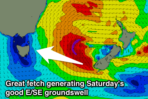 Of greater importance is a much better and broader fetch of gale to severe-gale SE winds forming off and west of New Zealand's South island tomorrow evening and Friday morning.
This should produce a strong E/SE groundswell for Saturday (with a late pulse like Friday to 3ft at open beaches), peaking in the 3-5ft range through the morning, and easing back into the afternoon, further from 2ft to maybe 3ft Sunday morning.
Conditions are looking great over the weekend with fresh offshore NW winds Saturday and W/NW Sunday.
Longer term a good S'ly groundswell is likely Tuesday morning, generated by a strong polar low forming south-west of the state on the weekend, with it lingering to our south-east through early next week, generating plenty of swell.
More on this Friday though.