South facing beaches the pick over the coming week

Eastern Tasmania Surf Forecast by Guy Dixon (issued Monday 11th April)
Best Days: Friday
Recap:
We didn't see much size over the weekend, but the lack of swell was made up for by the offshore breezes and clean conditions that persisted each day.
We have seen a strong increase in swell throughout today however as a mix of southerly wind swell and more substantial groundswell has filled in. The short range energy has been whipped up by broad southwesterly trailing fetches following a strong frontal progression moved locally overnight, while the longer range swell was generated by a southwesterly captured fetch which has been sling-shotting towards Tasmania since late last week.
Conditions remained clean for the better part of the day with seabreezes only kicking in after lunch.
This week (Tuesday 12th - Friday 15th) and weekend (Saturday 16th - Sunday 17th):
Southerly energy will continue to be the dominant source of energy in the coming week, although poorly aligned with only sideband energy being the main contributor.
A weak front will steer a small southwesterly fetch south and east of Tasmania this evening, although modest in size and intensity. This system is pretty insignificant, but should help to slow the otherwise easing trend on Tuesday.
South facing beaches should see the surf ease from the 3ft range, preceding the next slight period pulse which is due on Wednesday generated by less than ideal fetch which is more favourably aligned for far southern parts of New Zealand.
Sideband energy off this fetch will only be modest, with south swell magnets picking up inconsistent 1-2ft sets on Wednesday, with slightly more size off the following system, around 2ft on Thursday.
Westerly breezes are on the cards for Tuesday morning, gradually swinging southeasterly as the day progresses. Wednesday should see a brief opportunity of a clean wave during the early morning under a southwesterly breeze, before a northeasterly seabreeze develops soon after. Thursday is looking better for longer, with a light northwesterly breeze only giving way to a north/northeasterly seabreeze periodically throughout the day.
A small and weak north/northeasterly fetch looks increase and stretch southward form the South Coast of NSW on Thursday afternoon, persisting overnight as the southern extension shifts offshore.
Open beaches should pick up modest peaks in the 2ft range on Friday as a result, remaining clean all day under a northwesterly airflow.
A final frontal progression looks to traverse the Southern Ocean, clearly visible on forecast models southwest of WA before intensifying south of Tasmania on Friday.
While the alignment still isn’t perfect, the sheer size and strength of the southwesterly fetches should provide sets in the 2-3ft range for south swell magnets late on Sunday, although lacking quality as a southeasterly breeze persists.
Next week (Monday 18th onward):
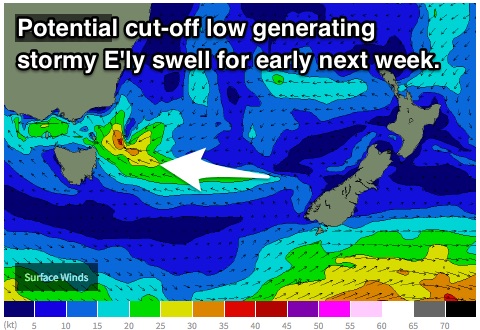 Models are suggesting that a small scale low has the potential to cut-off within a trough off the South Coast of NSW late on Sunday, which would in turn set up a local east/southeasterly fetch aimed right into the east coast of Tasmania.
At this stage, the fetch looks to linger for over 24 hours, increasing with core winds of around 30kts. In this scenario, open beaches would likely options build to the 3-5ft range on Monday, although stormy and wind affected due to the local nature.