Open beaches looking good from Friday onward

Eastern Tasmania Surf Forecast by Guy Dixon (issued Wednesday 20th January)
Best Days: Friday morning. Saturday, Sunday, Monday and Tuesday at open beaches.
Recap:
Not much to talk about in the recap, with tiny 1ft options yesterday, fading to virtually nothing today. Conditions remained clean for a small amount of time on Tuesday, with seabreezes kicking in before 8am. The situation was marginally better today, staying cleaner for longer, but no serious swell.
This week (Thursday 21st - Friday 22nd) and weekend (Saturday 23rd - Sunday 24th):
South facing beaches hold the best prospects of a wave on Thursday, albeit small. A poorly aligned, but fairly strong frontal progression is due to move over the Southern Ocean late on Wednesday into Thursday, providing a building southerly groundswell across the magnets.
By the afternoon, sets should be in the 1-2ft range relying mostly off sideband energy.
Conditions look to start off clean under a northwesterly breeze, remaining that way up around St Helens, however Scamander and Bicheno look to see an afternoon seabreeze develop.
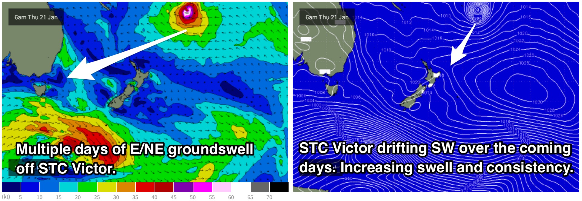
Friday should start to see the first signs of a very long range east/northeasterly swell generated by Severe Tropical Cyclone Victor. Victor has been lingering over the tropical South Pacific over the past few days and is forecast to move in a southwesterly direction, becoming more favourable for eastern Tasmania. As this system drifts southward we expect to see more size and a slight increase in consistency.
We should begin to see very inconsistent sets build to the 2ft range across the open beaches by the afternoon with northwesterly breezes holding throughout the majority of the day at St Helens, seabreezey once again in the afternoon further south.
 Northerly fetches which are forecast to sit off the coast of NSW until late Friday have the potential to add a tiny amount of northeasterly energy into the mix as we move into the weekend, however the alignment its less than ideal and their intensity is lacking.
Open beaches should see a the first indications of this northeasterly swell on Friday afternoon, with peaks in the 1ft range, but most of it should break throughout Saturday with options in the 1-2ft range, fading from a similar size on Sunday.
This swell is likely to be overshadowed by the bigger sets generated by Victor which are forecast to move into the very inconsistent 2-3ft range on Saturday and the 3ft+ range on Sunday, however, the small northeasterly swell will provide smaller options while you wait.
In terms of winds, Saturday is looking light, but generally onshore, swinging from south/southeasterly early through to north/northeasterly by the afternoon.
Sunday looks to start off light/variable-south/southeasterly, increasing from the southeast in the afternoon.
Next week (Monday 25th onward):
Victor’s east/northeasterly groundswell looks to continue into the early stages of next week, likely being the dominant source of decent swell. Monday and Tuesday should hold in the 3ft+ range off this swell alone, with the potential for a short range southerly windswell following a change.
There is a fair amount of model disagreement regarding the timing of this southerly change, with some models picking Monday morning, while others picking Tuesday morning.
In either scenario, open beaches are the go, finding protection from the southerly when needed.