Weak NE windswell, with more promising E/NE groundswell late week

Eastern Tasmania Surf Forecast by Guy Dixon (issued Monday 18th January)
Best Days: Each morning, especially Friday.
Recap:
South swell gradually faded throughout the weekend, with options in the 2ft range across the magnets on Saturday, grading to 1-2ft on Sunday and a merely 0.5ft today.
Each morning has offered clean conditions under light northwesterly breezes, persisting until late morning on Sunday and today.
This week (Tuesday 19th - Friday 22nd):
A small and weak northerly fetch developed late on Sunday evening and has been increasing along the east coast of Tassie today. Although very modest, 20-25kt winds look to extend north to the mainland later this evening, leading to a small amount of northeasterly windswell for Tuesday.
Open beaches are looking at building to the 1-2ft range on Tuesday morning, holding in that range as the impacts of the tail end of this fetch fill in.
Light winds look to prevail from the northwest in the morning, before giving way to a light easterly seabreeze in the late morning and early afternoon. On dark, winds look to drop once again.
The majority of this swell should have dried up as we move into Wednesday morning, with just tiny background energy preventing the ocean from falling completely flat.
A subtle pulse of southwesterly groundswell should fill in across the more exposed south swell magnets, allowing options to build to the 1ft+ range by the late afternoon off a poorly aligned but broad fetch of 25-30kt southwesterly winds.
The details of the wind outlook aren’t overly relevant, but the time of lightest winds will be the early morning under a northwesterly flow, before swinging southeasterly and increasing later.
Thursday should hold at a similar size, perhaps just cracking the 1-2ft mark off the same system, before being superseded by a more dominant building east/northeasterly groundswell.
Winds look to cooperate all day, persisting from the northwest around St Helens, perhaps light onshore further south.
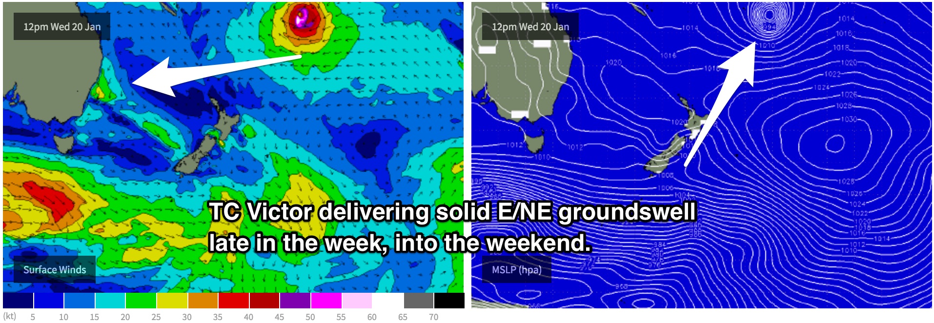
A long range groundswell should then build across the region, generated by Tropical Cyclone Victor which has been residing over the tropical South Pacific near Fiji, similar to Tropical Cylone Ula, just stronger.
East/northeasterly groundswell looks to provide very inconsistent sets building to the 2ft range across the open beaches by Friday afternoon under a light/variable onshore airflow.
Meanwhile, a second pulse of southerly groundswell should also fill in across the magnets on Friday, generated by a slightly more favourable frontal progression.
This weekend (Saturday 23rd - Sunday 24th):
At this stage, Victor is forecast to follow a slow track southward leading into the weekend, allowing consistency to improve and size to increase slightly throughout the later stages of the weekend.
The periods between waves won’t be completely flat, with undersized northeasterly swell filling in from a modest, disjointed fetch which is due to develop off the coast of NSW on Tuesday, sustaining until Thursday.
Open beaches can look forward to slow but solid sets in the 2-3ft range on Saturday, building and becoming more reliable on Sunday into the 3ft+ range.
Saturday is looking at a light/moderate southerly breeze throughout the day, tending easterly later, while Sunday can expect a less favourable moderate southeasterly breeze.
Next week (Monday 25th onward):
Victor’s east/northeasterly groundswell looks to be the best and most dominant swell into the early stages of next week, so open beaches will be the place to keep an eye on for occasional sets in the 3ft+ range.