Multiple swells in the water to end the week

Eastern Tasmania Surf Forecast by Guy Dixon (issued Wednesday 13th January)
Best Days: Friday morning possibly Monday morning.
Recap:
Not much to report for Tuesday with tiny conditions under 1ft for most spots and poor southerly breezes tending easterly throughout the day.
Today has shown more promise, with fresh but inconsistent south/southeasterly groundswell building to the 3-4ft range across the magnets, with a wind affected northeasterly windswell elsewhere. Conditions remained super clean this morning under a light northwesterly ariflow. South swell magnets are the pick for the rest of today.
This week (Thursday 14th - Friday 15th):
Multiple swell sources are likely to be breaking across Tassie’s east coast on Thursday.
Firstly, today’s pulse of southerly groundswell generated by a small but intense low which sat off the edge of the Antarctic ice shelf earlier in the week will fade, with inconsistent sets easing from the 2-3ft range across the south swell magnets.
A northeasterly windswell which has been building throughout today from a 30-35kt northerly fetch spanning eastern parts of Bass Strait is expected to peak in the morning, with open beaches fading rapidly from the 3-4ft range.
Underlying inconsistent east/northeasterly energy will also fill in throughout the day from Tropical Cyclone Ula as she moves in a southeasterly direction over cooler waters. Open beaches should see occasional sets in the 2-3ft range, although likely overshadowed by the northeasterly windswell.
Finally, a gusty southwesterly change is set to move over throughout the day, although not really bringing many direct impacts to the coast until the late evening when breeze tend southerly. Nevertheless, a short range southerly windswell should build across the exposed magnets to the 1-2ft range by the late afternoon.
Breezes are looking good for the morning, session particularly along the coasts north of St Helens where a westerly airflow is set to dominate. Further south from Scamander to Bicheno, breezes look to be stronger and from the southwest.
As the afternoon progresses, breezes should tend southerly limiting options to the open beaches, particularly in the south. Further north, models show the potential for a southeasterly afternoon airflow.
The shortrange southerly windswell swell should build to a peak on Friday morning at around 3ft across the exposed south swell magnets.
By this stage, the northeasterly windswell should have virtually subsided, with only east/northeasterly Ula energy and inconsistent polar low energy filling in.
Although south facing beaches are likely to be seeing all the size, the quality is not likely to be anything special, with a southerly breeze dominating throughout the day. Open beaches will have much cleaner options, although smaller and slow.
This weekend (Saturday 16th - Sunday 17th):
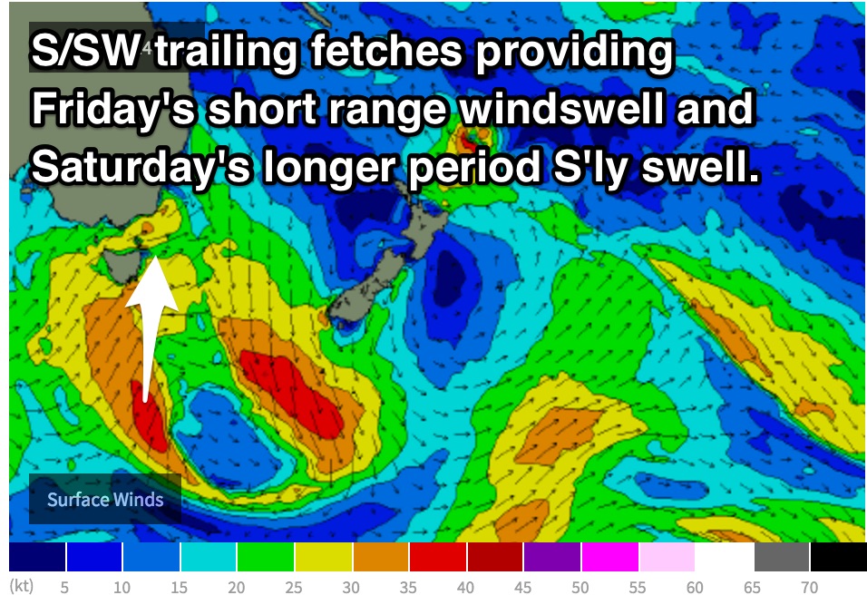 A southerly swell from core fetches associated with Thursday's change should fill in acress south facing beaches on Saturday morning, providing options in the 2-3ft range, fading thereafter. Open beaches should see inconsistent sets in the 1ft range.
Light offshore winds are on the forecast early, before giving way to a light easterly seabreeze.
Sunday should ease from the 1-2ft range across south swell magnets, without many options for a wave elsewhere. Again, winds look to be light northwesterly early, tending northeasterly later, gusty towards Bicheno.
Next week (Monday 18th onward):
A Tasman low forming on Friday looks to provide good southeasterly energy for NSW by Monday, however the impacts for Tassie will be less, merely sideband energy in the 2ft range for the open beaches into the afternoon under a light northwesterly breeze early, tending gusty northeasterly later.
Further ahead, a ridge looks to build over the Tasman allowing for a northerly fetch to develop off the coast of southern NSW and Bass Strait. A modest northeasterly windswell is on the cards for the open beaches mid-way through the week, with favourable winds forecast as this fetch pushes offshore.
More detail on Friday.