Good S/SE groundswell building Wednesday, easing with a NE windswell Thursday

Eastern Tasmania Surf Forecast by Guy Dixon (issued Monday 11th January)
Best Days: Wednesday and Thursday
Recap: Easing southerly swell from 2ft with offshore winds Saturday, with not much on offer Sunday.
This week (Tuesday 12th - Friday 15th):
The effects from Tropical Cyclone Ula look to be the most dominant source of swell on Tuesday, providing very inconsistent sets in the 1-2ft range across the open beaches. It's not much, but without this system, the situation would be pretty grim.
Light/moderate winds look to persist from the south/southeast, strengthening and tending more southeasterly throughout the day, so protected southern ends of the open beaches will be the go.
Wednesday holds much better prospects for a wave, with south facing beaches becoming the focus.
In Friday's forecast, we mentioned the possibility of a small but intense low pressure system sitting off the ice shelf of Antarctica and to our delight, the system came off. Satellite passes over the area show 50kt winds sustained for around 24 hours with good alignment to Tassie.
The long range nature of this system means that consistency is likely to be an issue, however south facing beaches still have the potential to build into the 3-4ft+ range by the afternoon.
Meanwhile, a ridge building over the region should result in a strengthening north/northeasterly airflow down the coast. We are looking at a 12 hour period from Wednesday morning until late Wednesday evening of north/northeasterly breezes increasing to around 25-35 knots.
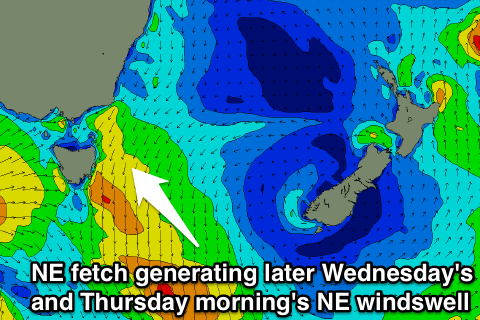 The surf across open beaches should build to around 3ft by the late afternoon, before a peak early on Thursday morning at around 3-4ft.
Conveniently, south facing beaches look to offer the cleanest conditions on Wednesday as gusty north/northeasterly breezes dominate the coast.
Thursday however looks to start off under a west/northwesterly airflow with big clean peaks along the open beaches, deteriorating in the afternoon as a breezes swing southwesterly.
Finally, a southerly change is due to move up the coast overnight from Thursday into Friday, providing a strong kick in southerly windswell for the magnets on Friday.
We should see the surf build to a poor quality 3-5ft across the south facing beaches, heavily impacted by a gusty southerly breeze.
Unfortunately, the periods will be negligible, so refraction into more protected beaches is not looking likely.
More to come on Wednesday.