Clean and workable at south magnets for Saturday

Eastern Tasmania Surf Forecast by Guy Dixon (issued Friday 8th January)
Best Days: Saturday morning, possibly later next week.
Recap:
Conditions early on Thursday were nice and clean under calm winds as a 2ft east/northeasterly swell rolled in. Today, we’ve seen more size, with a southerly swell building across the magnets. The better part of the morning was pumping with plenty of size and good shape under a northwesterly airflow.
This weekend (Saturday 9th - Sunday 10th):
With the exception of long range easterly energy generated by Tropical Cyclone Ula over the past few days, the next most significant swell is a result of a strong frontal progression which moved over the Southern Ocean overnight.
A southerly groundswell is building across the exposed south swell magnets this afternoon, generated by a broad fetch of 35-45kt west/southwesterly winds which moved through the southern swell window late on Thursday.
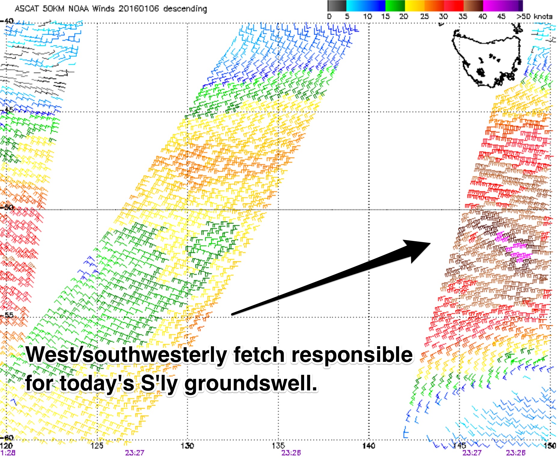 The alignment of this fetch was by no means ideal, however the size and disturbance of this system was sufficient for the 3-4ft swell we have this afternoon. By Saturday morning, we should be moving off the back of this swell, fading from the 3ft range.
For those who are hoping to get a wave early, winds look light and variable, tending northwesterly as the day progresses north of St Helens. However, further south around Scamander, an afternoon easterly breeze is due.
A second, smaller and equally poorly aligned system is due to move to the south of Tassie late this evening, into the early hours of Saturday morning, providing a secondary small pulse across the magnets on Sunday, although not much bigger than 1ft.
Meanwhile, inconsistent east/northeasterly energy from Ula will continue to fill in across the open beaches, providing occasional sets in the 2-3ft range on Saturday, slightly smaller on Sunday.
Sunday is looking to be onshore throughout the day, although very light early. As the afternoon wears on, a gusty east/northeasterly breeze should develop.
Next week (Monday 11th onward):
The early stages of next week look to remain fairly dormant, with the exception of Ula who just keeps on giving. Sure it’s not much, but without the inconsistent 2ft peaks across the open beaches, the surf would be almost flat.
Breezes look to start of light north/northwesterly, increasing from the north and eventually back to the northwest later.
The prospect of a northerly fetch developing off the coast of NSW is holding true, with 20-30kts sustaining from late Sunday until vary late Monday, with a slight intensification on Monday afternoon.
Southern, more local parts of this fetch look to push offshore before dawn on Monday, limiting the local swell generation potential. Nevertheless, we should see open beaches build to the 1-2ft range on Tuesday, unfortunately tarnished by a moderate south/southeasterly breeze throughout the day.
Looking further ahead, early indications show a long range south/southeasterly groundswell to build bringing the potential for some inconsistent but fun 3-4ft surf across the magnets. At this stage, the details of this swell remain a bit variable, so we will wait until next week to lock it in.