Weak swells ahead of some better NE and E/NE energy from Sunday

Eastern Tasmania Forecast by Craig Brokensha (issued Wednesday 30th December)
Best Days: Monday onwards
Recap
Tiny waves for the last couple of days, but we've got plenty of swell to come over the coming period!
This week and next (Dec 31 – Jan 8)
A developing but relatively weak N/NE fetch through this evening and tomorrow should kick up some new N/NE windswell tomorrow building from 1-2ft through the morning to a slightly bigger 2ft+ later in the day but with N/NW winds.
A S'ly change is now due to arrive earlier, moving up the coast Friday morning and this will see the NE windswell dropping slowly from the 2ft range across north-east facing beaches while a weak S/SE windswell builds.
This S/SE windswell will have no real power or size, peaking Saturday morning to 2ft+ or so along with poor S/SE tending SE winds.
 Of greater importance is a good pulse of E/NE groundswell that's due to build through Sunday, peak overnight and then slowly tail off Monday.
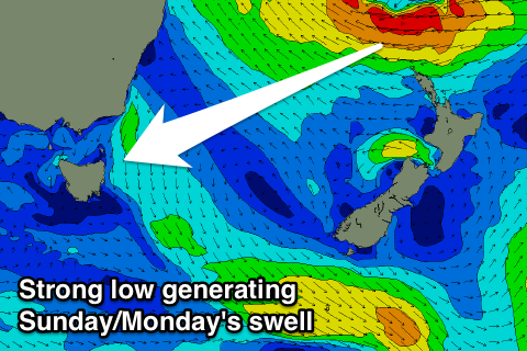
As talked about on Monday, an active monsoon trough in the South West Pacific has resulted in the formation of a broad low pressure gyre. Within this clock-wise rotating gyre, a strengthening embedded low is forecast to aim a fetch of E'ly gales through our north-eastern swell window while drifting south-west over New Zealand's North Island, before generating a weaker fetch of E/NE winds through our eastern swell window.
A good but inconsistent NE tending E/NE swell event should be seen, building through Sunday from 2-3ft or so through the morning to 3-4ft into the afternoon across north-east facing beaches, peaking overnight and then slowly easing from 3-4ft Monday morning, further from 2-3ft Tuesday.
We may see additional E/NE pulses if the low lingers off New Zealand, but we'll have to have a closer look at this on Friday.
Unfortunately winds on Sunday are expected to be onshore, with better offshore into Monday and Tuesday mornings.