Solid NE swell due on Saturday

Eastern Tasmania Surf Forecast by Guy Dixon (issued Wednesday 23rd December)
Best Days: Saturday morning/early afternoon at open beaches, then move to protected southern corners.
Recap:
We didn't see much in terms of swell on Tuesday, maybe 1-1.5ft at the exposed magnets under a persistent southerly breeze.
Today however, a small southerly groundswell is breaking across the coast this afternoon, with sets in the 2ft range at the magnets, smaller across the open beaches. Light northwesterly breezes kept conditions clean for the morning, before giving way to a northeasterly seabreeze.
This week (Christmas Eve Thursday 24th - Christmas Day Friday 25th):
A southerly groundswell will fade from today into Thursday, becoming tiny with only the odd 1ft peak breaking across the exposed south swell magnets.
Never fear, the outlook for surf is still positive, with plenty of size out of the northeast due to build late in the week.
A north/northeasterly fetch of 30-35kts is due to develop late on Thursday, extending from the South Coast of NSW, across eastern Bass Strait and right down the east coast of Tassie.
A northeasterly swell is expected to build strongly across the open beaches to the 4-5ft by the late afternoon of Christmas Day. Unfortunately, gusty northerly breezes associated with this fetch are likely to have a fairly substantial impact on the quality of the surf, creating bumpy and wind affected conditions.
This weekend (Boxing Day Saturday 26th - Sunday 27th):
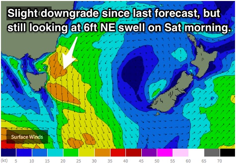 During the overnight hours from Friday into Saturday, models suggest a slight intensification northeast of Tasmania, creating a final pulse leading to a peak in size across the open beaches due Saturday morning.
The surf should peak in the 5-6ft range, potentially coinciding with a southerly change and a period of slack/offshore breezes.
There is still a fair amount of model disagreement regarding the timing of a change, however it looks to be sometime during the morning to early afternoon.
In either scenario, winds winds look to drop and tend offshore for a period of time as the wind change moves through. Keep in mind, there may bet a fair amount of residual chop/scarring in the mix from the fresh northerlies, however keep an eye out for a window of big, clean surf.
Following the change, gusty southerly breezes should limit options to the protected southern corners further south. Although easing, plenty of northeasterly energy is likely to still be in the water, fading fairly rapidly.
A small southerly windswell should build across the open beaches to around 2ft, although lacking quality due to the wind direction.
Sunday should see the small amount of southerly energy peak across the exposed south facing beaches generated by the wind change the previous day. The swell magnets should hold in the 2ft range during the morning, easing thereafter.
Winds are forecast to prevail from the south/southwest early, swinging through to the southeast by the afternoon, so hit it early for a wave of variable quality.
Next week (Monday 28th onward):
The start of the following week isn’t looking especially exciting, with all potential swell sources showing poor alignment. Most locations should see subtle ebbs and pulses to around 1ft off background energy.
Next forecast due Christmas Day. Until then, happy holidays.