Plenty of surf for the week to come

Eastern Tasmania Surf Forecast by Guy Dixon (issued Monday 26th October)
Best Days: Tuesday morning, Wednesday morning, Thursday morning and Sunday morning.
Recap:
The weekend started off slow with small and weak peaks only just managing to crack the 1ft mark at south facing beaches. On the plus side, winds were light out of the northwest for the early session and kept conditions clean and workable for those on big boards. Breezes soon swung onshore and it was done for the day. Sunday brought a touch more size and cleaner conditions under warm northwesterly breezes. South facing beaches were picking up workable peaks in the 1-2ft range.
A southerly flow has been increasing throughout the day following a change overnight. The surf is increasing as we speak and is currently sitting in the 2-3ft range. Quality is poor however and there are very few options for a workable wave. Unfortuately the protected south ends are the only spots that are clean, but missing out on virtually all the size.
This week (Tuesday 27th - Friday 30th):
Short range energy is expected to rapidly ease off the back of today’s strong southerly flow, however an underlying southerly groundswell from stronger core fetches of 40-45kt winds peak on Tuesday morning providing surf in the 4ft range at exposed south facing beaches.
The early session on Tuesday will be the pick of the bunch under light/variable breezes. There is the chance of some residual surface scarring left in the mix, but conditions will be at their best before breezes increase and swing around to the northeast by afternoon.
The surf will fade from the 2ft range throughout Wednesday preceding another pulse of southerly groundswell on Thursday. Again, the morning session is looking good under light northwesterly breezes, tending light northeasterly later in the day.
A broad fetch of poorly aligned west/northwesterly winds ahead of a polar front will move south of Tasmania throughout Tuesday, while smaller, more intense westerly core fetches will follow in the wake of this system. All this activity will contribute to a southerly groundswell which is expected to build into the 2-3ft range at south facing beaches on Thursday afternoon. Again, due to the swell direction, open beaches will be significantly smaller.
Winds are expected to be light southwesterly early, before adopting a moderate southeasterly flow, eventually tending east/northeasterly in the afternoon.
Despite easing marginally on Friday, weak but continuous frontal activity will keep a steady stream of background southerly energy filling in for the remainder of the week. South facing beaches should continue to provide surf in the 2ft range on Friday and will also offer the cleanest options under an increasing northeasterly breeze.
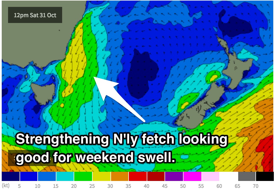 This weekend (Saturday 31st - Sunday 1st):
Small remnants of southerly groundswell are likely to be overshadowed by fresh energy over the weekend.
A north/northeasterly flow is expected to increase off the coast of NSW and across eastern parts of Bass Strait late on Monday and into Saturday morning providing a more dominant north/northeasterly groundswell for the weekend.
We should begin to see the impacts of this north/northeasterly swell at open beaches on Saturday afternoon with peaks in the 2-3ft range. As we move into Sunday, the swell will increase to the 3ft range at open beaches with winds looking favourable virtually all day.
Unfortunately Saturday is likely to be plagued by north/northeasterly breezes, so if you look for shelter you’ll also be sacrificing size. However, Sunday is looking better in terms of winds, particularly in the morning.
Winds should prevail from the west early, increasing from the north in the afternoon.
More detail/any updates to come in Wednesday’s notes.