Small NE swell tomorrow then S'ly swell from Wednesday (strongest Thursday)

Eastern Tasmania Forecast by Craig Brokensha (issued Monday 13th September)
Best Days: North-east swell magnets through tomorrow, south swell magnets Thursday
Recap
Tiny clean waves all weekend, while today a small increase in N/NE windswell was downgraded over the weekend. This was tiny this morning, and a slight kick to 1-2ft has been seen this afternoon but with average onshore N/NE winds.
This week and weekend (Sep 15 - 20)
Small levels of NE windswell are due to persist through tomorrow to 1-2ft across north-east facing beaches, generated by a persistent fetch of elongated N/NE winds off the Southern NSW coast this evening and early tomorrow.
Conditions should be much cleaner as well with a W/NW tending fresh W/SW and then SW breeze.
 This change in wind direction will be related to a strengthening surface trough pushing up past the coast, and a small kick in S'ly windswell is due from it on Wednesday, reaching 2-3ft across south facing beaches early, easing through the day.
Conditions are due to improve through the day though with a W/SW tending variable and then NE breeze.
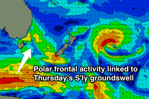
Into later Wednesday and more so Thursday a new S'ly groundswell is due across south facing beaches, with it currently being generated by a vigorous polar frontal progression to the south-southwest of the state.
While not perfectly aligned, we should see inconsistent but good 2-3ft sets across south facing beaches through the morning, easing into the afternoon and further Friday.
Conditions are lining up nicely with a W/NW tending N'ly breeze, so aim for the morning surf, while Friday looks average as a shallow S/SE change moves through.
Longer term there's nothing significant due into the weekend and the outlook beyond this is tricky with some troughy weather due across Eastern Australia into the following week, but check back here on Wednesday for the latest on this.