Good S'ly swell for the weekend, best Sunday

Eastern Tasmania Forecast by Craig Brokensha (issued Friday 17th July)
Best Days: Saturday protected spots, Sunday
Recap
Good pulse of S/SE swell to 3-4ft yesterday with offshore winds, before easing into the afternoon and dropping further from 2ft on the sets this morning.
A new pulse of S'ly windswell should have been seen this afternoon with a S'ly change but to no decent quality.
This weekend and next week (Jul 18 – 24)
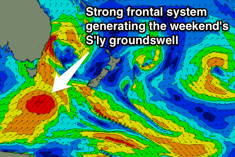 A vigorous polar front is currently projecting north-east up through our southern swell window, producing a fetch of S/SW gales.
This should produce a strong pulse of S'ly groundswell for tomorrow, peaking into the afternoon to 4-5ft+ across south facing beaches with early W/SW tending S/SW winds.
Sunday will be much better as the S'ly swell eases from 4-5ft under excellent W/NW winds.
Make the most of Sunday as by Monday there's no real size due to be left with fading 1ft to possibly 2ft sets at south swell magnets.
Into the rest of next week there's nothing major on the cards, beside small and weak levels of N/NE windswell.
We'll have a closer look at this on Monday though. Have a great weekend!