Good E/NE swell building Monday, easing Tuesday

Eastern Tasmania Forecast by Craig Brokensha (issued Friday 10th July)
Best Days: Monday, Tuesday
Recap
Good pulse of S/SE swell keeping 3ft to occasionally 4ft waves hitting the coast yesterday with offshore winds, while the swell was on the ease from 1-2ft today.
This weekend and next week (Jul 11 – 17)
 There's nothing major due on the weekend, with only a small to tiny NE windswell possible through tomorrow afternoon and similar weak SE windswell for Sunday afternoon with average winds.
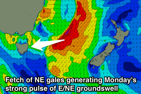
The strong cold outbreak occurring across the south-east of the country is due to see an infeed of NE to E/NE gales aimed towards us through Sunday. This should produce a strong pulse of E/NE swell for Monday, building to 4-5ft across open beaches with offshore SW tending W/SW winds.
The swell will drop into Tuesday to 2-3ft, but may then linger Wednesday around 2ft or so across open beaches.
There's no real sizey S'ly swell due, with some smaller but fun S/SE swell on the cards for Thursday to 2-3ft or so. We'll have a closer look at this Monday though. Have a great weekend!