Fun S/SE swell with improving winds

Eastern Tasmania Forecast by Craig Brokensha (issued Monday 6th July)
Best Days: Wednesday, Thursday, Friday morning
Recap
Easing swell Saturday but with a good kick in size yesterday with generally favourable winds.
Today the swell was reported to only be 2ft, way under expectations and with poor winds, which were to be expected through the day, but not at dawn. The swell should have kicked a little into this afternoon, but we've got some fun S/SE swell on the way for the rest of the week in any case.
 This weekend and next week (Jul 2 – 10)
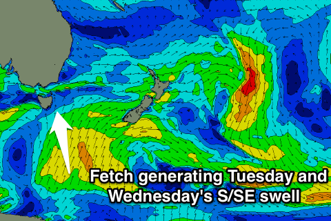
Currently a strong fetch of S'ly winds are being projected up from the polar shelf towards the southern Tasman Sea, through our southern swell window.
This should produce a moderate sized S/SE swell, building tomorrow afternoon and peaking Wednesday morning.
South facing beaches should build to 3-4ft through the afternoon, and then hold a similar size Wednesday morning, before easing slowly through the end of the week. Thursday should ease from 3ft, with smaller 2ft waves Friday morning.
Winds tomorrow will remain poor with a S/SW tending S/SE breeze, with better NW tending N'ly winds Wednesday and persistent NW breezes Thursday.
This weekend onwards (Ju 11 onwards)
A weak S'ly change on Sunday should bring with it a small pulse of S'ly windswell, but this will be linked to a stronger cold out-break across the south-east of the country, with a stronger burst of S'ly gales due to develop off the coast early next week. This will produce some junky S'ly swell, but we'll discuss this in more detail Wednesday.