Great surf from Friday

Eastern Tasmania Forecast by Craig Brokensha (issued Wednesday 17th June)
Best Days: Friday, Saturday, Sunday morning
Recap
Easing but workable waves out of the S/SE yesterday morning with a building windswell late in the day. This NE windswell peaked this morning with fun 2-3ft waves across north-east facing beaches under light SW winds which strengthened through the day. This should of kicked up a late increase in S'ly swell but with no quality.
This week and weekend (Jun 18 - 21)
This afternoon's strong S'ly change is associated with a strong and broadening frontal system pushing into the southern Tasman Sea, and we'll see this aim a broad fetch of strengthening and anti-clockwise swinging fetch of SE tending E/SE winds through our swell window this evening and tomorrow.
This should create plenty of S/SE tending SE and then E/SE swell over the coming few days.
Tomorrow should see short-range S/SE swell to 3-5ft but with strong but easing S/SE winds.
Friday will be better with the swell swinging more SE and easing from 3ft to possibly 4ft under offshore W'ly tending SW winds.
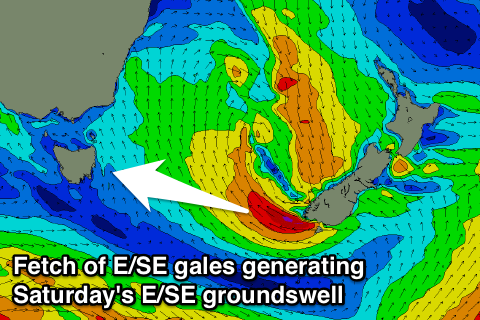
One final pulse of E/SE groundswell is then due Saturday morning from a fetch of E/SE gales off the tip of New Zealand's South Island, with open beaches due to see inconsistent but strong 3-4ft sets again before easing into the afternoon and further from 2ft+ Sunday under W/NW winds.
Also in the mix Saturday with be a strong S'ly groundswell from a vigorous polar low pushing in from the west currently, with south facing beaches due to see 4-5ft sets through the middle of the day afternoon, before easing back from 2-3ft Sunday morning.
Longer term another small S'ly groundswell pulse is due Monday but to no major size with some S'ly windswell mid-week, but we'll look at this closer on Friday.