S'ly swells ahead of a strong S/SE groundswell next week

Eastern Tasmania Forecast by Craig Brokensha (issued Wednesday 10th June)
Best Days: Thursday, Friday afternoon, Monday, Tuesday
Recap
Flat conditions today and a small sign of new S'ly swell this morning which should of kicked better this afternoon. The alignment of the front generating this swell seemed to not play out as perfect as forecast Monday, with sets more in the 3ft range likely later today.
This week and weekend (Jun 11 - 14)
Any kick in swell seen this afternoon should ease back through tomorrow from 2-3ft at south facing beaches under favourable W/NW tending W/SW winds.
Friday morning is expected to be tiny, but an afternoon kick in small S'ly groundswell is due from a strong and broad polar front passing under us this evening and tomorrow.
This should see south facing beaches kick back to 2-3ft under great W/NW tending N/NW winds.
Come Saturday the swell is expected to be effectively gone with tiny conditions for the rest of the weekend. Later in the day Sunday we may see a new S/SE groundswell pushing in, but this is discussed in more detail below.
Next week onwards (Jun 15 onwards)
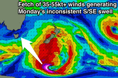
The frontal system responsible for Friday afternoon's groundswell is expected to stall and form into a broad and powerful low pressure system under New Zealand during Thursday evening and Friday.
With this a fetch of severe-gale to storm-force S/SE winds should be aimed and projected through our swell window, generating a strong pulse of S/SE groundswell that may be seen later Sunday, with a peak due through the afternoon Monday.
Exposed breaks should build to a strong and powerful 4-5ft+ through Monday with favourable W/NW tending NE winds. A slow drop in size is then due from Tuesday from 3-5ft, down further from 2ft+ Wednesday. Some NE windswell may also be in the mix from a strengthening fetch of NE winds off our coast, but we'll have a closer look at this on Friday.