Short-lived southerly swell pulse

Eastern Tasmania Forecast by Craig Brokensha (issued Friday 6th June)
Best Days: Wednesday afternoon, Thursday
Recap
There was nothing left into Saturday from the good SE groundswell seen late week, and since then the surf's remained tiny to flat.
 This week and weekend (Jun 9 - 14)
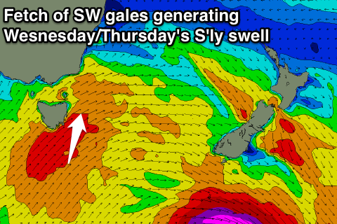
The structure of the strong frontal system currently pushing across us has changed a little since Friday and we're now not likely to see any considerable size across our region until Wednesday.
This will generated by a broad fetch of weakening SW gales pushing up past us Tuesday evening and early Wednesday morning.
A moderate sized S'ly groundswell is due, peaking through the afternoon to 3-4ft across south facing beaches, before easing back from 2-3ft Thursday morning.
Winds Wednesday are not the greatest with a fresh to strong SW'ly during the morning, but this is due to straighten out from the W into the late afternoon, opening up options for a late surf.
Thursday looks great with W/NW tending W'ly breeze.
Into the end of the week, another vigorous and more zonal polar front isn't expected to provide any major size Friday afternoon, with the odd 1-2ft set possible at south swell magnets.
Into the weekend and next week tiny surf is due, so try and make the most of Wednesday and Thursday's S'ly swell pulse.