S'ly swell to dominate period

Eastern Tasmania Forecast by Craig Brokensha (issued Wednesday 6th May)
Best Days: Friday, Wednesday morning, Thursday week
Recap
Rapid drop in NE swell from Monday's good pulse with average 2ft leftovers into yesterday morning. Today the surf was flat with a stiff offshore, due to the in-feed of NE winds through our swell window being cut-off.
 This week and weekend (May 7 - 10)
Unfortunately the in-feed of E/NE winds below New Caledonia and Fiji didn't develop as well as was forecast last Friday and as a result we'll only see tiny, inconsistent 1ft waves across north-east swell magnets through the coming days before fading into next week.
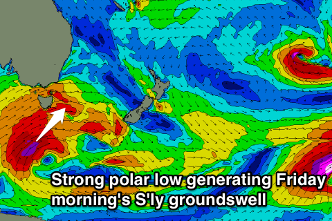
A better S'ly groundswell is due Friday morning though, generated by a vigorous polar low firing up below the state this evening, projecting a fetch of severe-gale to storm-force S/SW winds up through our southern swell window.
A peak is due Friday morning, coming in at 3-5ft across south swell magnets, with much smaller surf at open beaches to 2ft. Conditions should be good all day with strong W/NW winds.
The swell will drop rapidly into the afternoon with nothing significant due to be left into Saturday morning.
There's nothing significant due until Tuesday next week as another frontal system crossing us takes a better north-east track up past our coast while generating a fetch of SW gales.
This swell won't be as big as Friday's with south facing beaches due to build to 3-4ft along with poor SW winds. A drop in size is due from 3ft+ or so Wednesday with better W/NW winds ahead of an afternoon and strong W/SW change.
This will be related to a very strong cold outbreak pushing up across the state, with a large S'ly groundswell due to be generated for Thursday. This is still moving around a bit though, so check back here on Friday for another update.