Flat week, long-range swell next Wednesday

Eastern Tasmania Forecast by Craig Brokensha (issued Monday 9th March)
Best Days: Wednesday next week, better options on the South Arm
Recap
Saturday saw Friday's S'ly swell drop back in size from 2ft at open beaches, with larger 3-4ft sets at south swell magnets under offshore winds. Another kick in S/SE swell was reported through the day though, and this must of come off the backside of the low as it pushed east.
A rapid drop in size was seen overnight though leaving 2ft of easing SE swell across the coast.
Today the coast is near flat but nice and clean.
 This week and weekend (Mar 10 – 15)
Unfortunately there's nothing significant at all on the cards for this week with the storm track remaining too zonal (west to east) in nature for us to receive any decent S'ly swell.
Into the weekend, a better aligned but weak front pushing up past us early Sunday should kick up a weak S'ly swell for the afternoon to 2ft+ across south facing beaches but with poor SE winds.
The swell is due to fade Monday under early NW breezes.
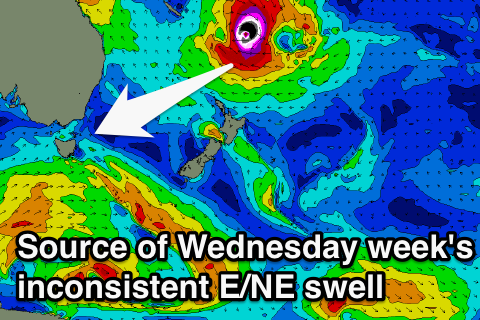
Longer term we're likely to receive some distant and very inconsistent E/NE groundswell from the tropical developments in the Western South Pacific ocean later this week and weekend.
A strengthening trade-flow is due to develop from Thursday evening as an intense tropical cyclone drifts south from the Vanuatu and Fiji region, squeezing the northern flank of a strong high pressure ridge sitting across New Zealand.
Unfortunately the strongest winds will be shadowed by New Zealand's North Island, but through Saturday we should still see a fetch of E/SE gales aimed on the periphery of our swell window.
The swell from these developments is likely to arrive late Tuesday but peak through Wednesday to a very inconsistent 3ft or so on the sets. We'll have a closer look at this on Wednesday though when the models should start firming up on the cyclones track and intensity into the trade-flow.