Fun S/SE swell tomorrow morning, NE swell for the rest of the period

Eastern Tasmania Forecast by Craig Brokensha (issued Monday 19th January)
Best Days: Tuesday morning, Wednesday onwards northern corners (more open beaches Friday)
Recap
The weekend failed to provide any decent surf with the swells seen late last week fading away to nothing. A fresh pulse of S'ly groundswell due today came in as expected with good 2-3ft waves pushing up the coast with early favourable winds before onshores kicked in mid-late morning.
 This week and weekend (Jan 20 - 25)
This morning's S'ly groundswell should be replaced by a secondary pulse of S/SE groundswell tomorrow morning, generated on the backside of the frontal progression responsible for this morning's swell.
We should see this keeping south facing beaches kicking in the 3ft+ range with 2ft+ sets at open beaches.
Winds will be best for northern corners though with an early N/NW breeze before strong N/NE winds kick up through the day.
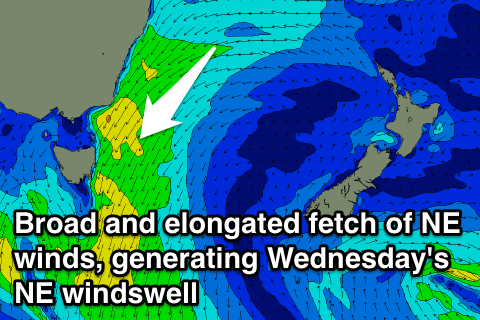
These strong N/NE winds will be linked to a broad and elongated fetch of strong NE winds extending from the Southern NSW coast down and past our region, generating a solid increase in NE windswell later in the day tomorrow and Wednesday morning.
The winds aren't expected to reach the gale-force range as forecast last week, but we should still see north-east facing beaches kicking to the 4ft range later tomorrow and peaking during the morning Wednesday to 4-5ft.
Winds tomorrow as mentioned above will be poor but a weak trough trying to push across us Wednesday should see winds ease and tend more N/NW favouring northern corners, which will be a lot smaller and out of the swell.
The fetch looks to however re-develop through Thursday and persist into Friday morning, keeping smaller levels of NE swell hitting north-east facing beaches in the 2-3ft range into Thursday and Friday (more likely still around 3ft+ early Thursday).
Winds will generally persist from the NW to NE though with Friday seeing better W/NW winds.
Into the weekend a new pulse of NE trade-swell is due to fill in as a tropical depression in the Coral Sea squeezes against a ridge of high pressure in the Tasman Sea and dips south slightly.
This should produce a fetch of strong and persistent E/NE winds through our north-eastern swell window during the second half of this week, generating a fun pulse of short-range NE swell. The swell is expected to arrive later Saturday and peak Sunday to an inconsistent 3ft across north-east facing beaches. Winds look as if they'll persist from the northern quadrant though, but we'll review this again Wednesday.
Comments
afternoon ,
will there be a wednesday update this week or will the next one be on friday now ?
Not sure mate - Craig's away for the next two weeks so the task is left with me - and I'm pretty flat strap. I'll see if I can get some notes up later, but it's unlikely to happen Mon/Wed/Fri (with some luck, Tues and Thurs).