Small mix of swells with dicey winds, possible bigger swell Sunday/Monday

Eastern Tasmania Forecast by Craig Brokensha (issued Monday 8th December)
Best Days: Southern corners tomorrow, north of Bicheno Wednesday morning, southern corners Thursday morning
Recap
There was plenty of swell out of the SE over the weekend but conditions were poor with fresh and gusty onshore winds from the south-east quadrant. Today the trough responsible for the swell kicked up more size this morning and drifted south-east resulting in winds tending variable and the coast coming in at a fun and lumpy 3-4ft.
A drop in size should have been seen this afternoon with light to moderate onshores.
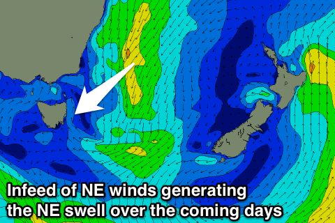 This week (Dec 9 - 12)
With the trough responsible for the current E/SE swell dipping away we'll see this swell drop overnight, easing from 2-3ft across open beaches through the morning.
Some long-range and inconsistent NE swell should be in the mix though, generated from a strong fetch of E/NE winds feeding into the Tasman Sea and into the eastern flank of the trough.
This NE swell should come in at an inconsistent 2ft to occasionally 3ft across north-east facing beaches tomorrow and Wednesday morning before easing off slowly through Wednesday afternoon and Thursday from 1-2ft.
Winds unfortunately look dicey with southern corners the pick as a S'ly change moves through early and winds swing more SE through the day. Wednesday also looks tricky with onshores expected across the Eagle Hawk Neck region, while from around Bicheno north a more variable breeze is expected before freshening from the NE. So surf early for the best of it.
The end of the week isn't looking too flash as another strong S/SE change moves through Thursday kicking up a weak S/SE windswell that will then ease Friday but into the weekend we've got some real interesting developments.
This weekend onwards (Dec 13 onwards)
During the end of this week a deep Tasman Low is forecast to form off the NSW coast and model guidance is firming up on a scenario where it deepens and then drifts south through the Tasman Sea over the weekend.
If this occurs we'll see a fetch of strong to gale-force E'ly winds projected through our eastern swell window producing a good pulse of E/NE groundswell building Sunday and then easing Monday peaking in the 3-5ft range.
There's still some divergence on this scenario though, so we'll review the forecast for the weekend and early next week again on Wednesday.
Comments
This low could get quite interesting..... It might pump big time....
If a passing front around ?! Monday /Tuesday next week does lose some vigour and the ridging high holdouts a little . Then yes even Tassie could get some decent Juice . Especially if it stalls as long as some of the outlining model runs !
Each run downgrades the swell from it for SE QLD so I'm not getting my hopes up too much. I imagine Steve will be but, given it's the death of the devil winds. And yes I agree that locations further to the south such as Sth NSW and east coast Tassie look to fair better (more so as the low moves SE).
Some early runs showed this low initially leaving the coast around Coffs-Byron instead of Central coast . One then had it not doing much then slowly drifting N NE then intensifying and SLOWLY drawing down into a stall equal with Sydney . ( basically as good as a NSW teenage surfer on W/ experience at BOM could dream up ) .... Don't get your hopes up , but the best scenario. Is half way between the two states ideal scenario . And I'm still of the opinion that'll it be on the better side of the surf scale .
A number of things.... As I pointed out to you, Southey, the trough has drifted further north up into qld..... Fraser Is thru to Alice' ish....
Now a few things are happening, but the "chlorine and brake fluid" has to bee right...
The "chlorine" ( lol cold air) needs to feed up from the south..... There is currently a source..... - fetch between Tassie and south NZ pushing up quite cold surface air (160e -45s)....
This cold air will sit off NSW.....
Brake fluid (warm moist air) will feed down the great divide from Qld to ACT on WEd...
As the next inland system drifts east on thurs', the chlorine and break fluid hit eachother....
But this initial Thursday low looks more like a "feeder".... A splinter low.... But it could serve a very important duty....What it will do is feed the unstable "pre mix" into a parent low.... The thurs' splinter low may then lose oomph, still surf though.......
Now the parent low looks like an unstable old girl.... Some models have it drifting off the sunny coast on Sunday.... Looking at the direction of that fetch late sunday onwards, plus the low then heading sse, there's the real possibility that next week east coast Tassie is the bomb.... And Mick free's favourite south NSW spot may be classic......
As the blind man says, "we'll see"......
.
Most likely outcome now is the low pushing east off the NSW coast resulting in hardly any groundswell for the East Coast of Tassie at all over the weekend from the E/NE (should be some E/SE swell from the fetch of the tip of the South Island).
As the low pushes across to New Zealand a good fetch of E'ly gales could generate a better E/NE groundswell pulse for Tuesday and Wednesday.
But there's still a lot of disagreement between the models, so making any firm forecast now is fraught with danger.
Yep, craig... That's the first low.. The "splinter low"..... But it's "mum" hopefully forms on sat/sun off seq.... The fetch I am talking about forms late sunday/Monday....
Sheepy, and what a volatile mix chlorine and brake fliud make !
Classic my next door neighbour strapped viles of some to a blokes car tryes he didn't like, when the bloke backed out the cocktail interacted and blew both his back wheels off..! I think he made up too much;)
I deny all allegations!!!!!! ;p
Sheepo , you just could of gone the " lemon next to the pie " ...
Instead of this Mother Daughter Tasmanian Terrorist act .
Bombs only work well when they are held to compression , and that there in lies with what i said in the first place . It needed a Stable strong High to cradle it .... And regardless of what the two crazy bitches do , without that Ridge they 'll just dissolve or fly off to the SE like the yanks in the 70's .
Bombs away . Access R (BOM's ) onboard .
Ahhh good old big Wednesday, Southey....
"Bombs only work well when they are held to compression , and that there in lies with what i said in the first place . It needed a Stable strong High to cradle it"...
Yep, I never once mentioned it would bomb on Thursday.... I did however say this..
" This next potential swell has a bit more intrigue to it... The potential swell from the low Southey was referring to is quite dependent on the high west of Tassie ridging up the nsw coast, and forming a decent fetch.... Point surf potential... Beachies blown out...." - 7/12/14... yep, it's all about the high and the fetch..
southey commented Saturday, 6 Dec 2014 at 9:24am
I'd hate to break up this storm watchers thread . But access is throwing it out there next Thurs-Friday onwards ..... This and the NNSW /SQld threads should shortly go into meltdown !!!!
And
southey commented Saturday, 6 Dec 2014 at 10:55am
I reckon anytime you get complex trough systems like this .
The size/ strength of the trailing high is imperative to a cut off forming .
Even though we are talking sub tropical , it needs that cradling high .
ATM , this snow sliding ,Lycra wearing , gym hating hipster reckons that something's gonna happen on the bullish side of the forecast spectrum. Otherwise I wouldn't have bothered poking my nose in a spot that will have no benefit from myself . Except from take the collective east coast populations eyes off the sky and back in the water ?!?
Southey, note above I wrote " The potential swell from the low SOUTHEY was referring to...."..
Now, the "trailing high" is not imperative.... A mixture of cold and warm air, upper level cold pool and the east coast current are the main driving factors.... An out of position high in the coral seas feeding in warm moist pacific air into the northern flank of the trough via a easterly trade ridge into qld can really spice things up..... A trailing high can cradle the low and point the well towards seq, but I am not writing in the seq forecast.. This is tasmania, mate ;)
Your initial low will do exactly as I have stated - ..... It wont "bomb", even though a perfectly good 1024h will be ridging up the NSW coast as it sits over Tassie... It will produce sizeable surf for NSW and QLD, but shit winds, so only protected points....
It will act as a feeder to the second low. This low (out of the 2 lows) is more likely to bomb, even though it has no "trailing high"........The preceding high ,,,, over NZ now, will cradle a fetch directly pointed down here.... NSW should also get a decent swell..... Local winds in both states look prime at this stage... They're often the hardest to get right.....
Ohhh, that's right .... "NNSW /SQld threads going into meltdown,,, nnnnnnow !!!! :) "6/12...... More troughiness to come is quite an entertaining read lol
i'm not going to go " there " as you just love arguiing !
I never stated that the ridge needed to extend up the NSW coast ... I don't give a flog about Qld getting anything . I said ( which helps all three coasts , in my honest opinion ) that high needs to maintain a ridge beneath any troughing which helps it feed out in the tasman . But once it gets far enough offshore then it needs to be cradled just west of NZ to make it worth while .
Clearly as soon as this happens then the Coral sea / waters sth of the Solimans , and east of New Cal , will inject their little tasty ingredients .
The lows / troughs were being sporned well out in the NWA , 4-6 weeks ago the coral sea and most of the ocean offshore Qld was sub normal temps . NSW , Vic and SA waters have been warm for months . Which has helped these troughs / coupled with the extreme early season continental heat to get them to drag accross still with plenty of oomph to deliver good storms .
Now that the QLd waters are starting to warm up due to the continental troughs advecting any moisture and maintaining cloudless skies over the Coral Sea , the SST's are following suit . And yes in some period ( after Thursday ) all hell will break loose at some time . As soon as that built up Qld oceanic energy is released then it'll be on liek Donkey Kong .
FYI , Even though people are distracted by the Northern Hem , surf orientated events , there has been far more traffic of interest of what will eventuate here ( East Coast in general . My inital comments were to encourage people to stop looking at teh sky in desperation . ;-)
i'm not going to go " there " as you just love arguiing !
Umm, you did go there.... You cut and pasted from there. lol
Stop clickbaiting, southey.... I wasn't "arguing", dude... I was clearly pointing out that I acknowledged you were the first to bring up this system with my quote "" The potential swell from the low SOUTHEY was referring to...."
The rest is general discussion on your and my opinion on ecls.... If you wish to take it as arguing, that's your call....
I won't extend this hyperbole, other than to point out that this solomans/new cal stuff you are talking about does not come into play with this particular system/s.... If I go on any further, you will interpret it as criticism....
I'm glad you noted water temp, and to some extent upper level moisture feeding in fro the Timor sea, which is essential, which I discussed at the formation of the first spring heat low over the Kimberley some weeks ago.... Anyway, I stand by my call.
Cheers, big ears......
its a love in ....
Yep... Stock up on KY......
Have a look at Monday -Tuesday GFS ....
Solomans /New Cal. moisture advection - bomb . !?!
Plenty enough lubrication to help you get a wave ...
Nope... Upper level and surface infeed at this very moment..... Check 140e 18s now..... trough moves east early Sat, area from 145e 20s to and including 158e 25s... Add retrograde of southeys "Thursday low" on late sunday....
Lube time....
Bomb !