Good Thursday, fading mix of swells Friday

Eastern Tasmania Forecast by Craig Brokensha (issued Wednesday 15th October)
Best Days: Thursday morning, Friday in protected southern corners
Recap
Yesterday a junky S/SE swell kicked up across the coast, spreading radially out from an East Coast low stalling off the Southern NSW Coast. This swell swung more SE through the day and eased back overnight, while a new E/SE pulse has filled in behind it from the bottom of the low.
This offered 2-3ft waves across the coast this morning with offshore winds and the swell should of built a touch further into this afternoon.
 This week (Oct 16 - 17)
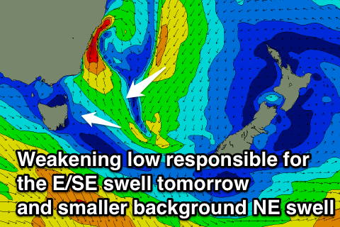
Today's building E/SE swell is expected to peak this evening and ease off through tomorrow as a result of the East Coast Low weakening and pushing off towards New Zealand.
Still, open beaches should offer 3ft sets through the morning under offshore winds ahead of a gusty S'ly change into the afternoon. Also in the mix should be small levels of E/NE swell from the eastern flank of the low, but not above 2ft or so.
Tomorrow's change won't have much strength behind it with only a weak 2ft+ wave expected across south facing beaches Friday with average winds from the southern quadrant.
This weekend onwards (Oct 18 onwards)
Friday's swell will fade overnight and there's nothing major due into the weekend with tiny surf expected across most breaks.
A small N/NE windswell may be seen Sunday but not above 1ft to maybe 2ft at exposed breaks.
Next week is looking a little more active as a stronger S'ly change overnight Sunday brings with a bigger pulse of S'ly windswell Monday. This will be with poor winds Monday, but Tuesday looks better with offshore NW winds through the morning as it eases.
Some larger NE windswell is then on the cards Wednesday, easing Thursday as a trough deepens to our north-east but more on this Friday.