Flat until a large powerful swell hits Friday

Eastern Tasmania Forecast by Craig Brokensha (issued Monday 29th September)
Best Days: Friday, Saturday, Sunday
Recap
Slight kick in S'ly swell Saturday that faded into Sunday under strengthening N'ly winds which kicked up a late increase in poor windswell. This windswell was backing away from 1-1.5ft today under fresh NW tending W'ly winds.
This week and weekend (Sep 30 – Oct 5)
There's nothing major at all on the cards for this week until Friday, but the swell due Friday is a good'en.
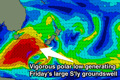 A series of strong fronts pushing across us over the coming days aren't expected to deliver any swell, but a strong node (peak) of the Long Wave Trough pushing across us and over the Southern Tasman Sea Wednesday will bring with it a serious weather system.
This will be in the form of a deep and powerful polar low firing up south-west of the state on Wednesday before being steered up towards New Zealand, past out coast on Thursday.
A broad fetch of severe-gale to storm-force SW winds will be generated within our southern swell window, aimed mainly towards New Zealand and Cloudbreak, but we'll still see large levels of side-band S'ly groundswell energy pushing up and into us on Friday.
The large swell periods will help the swell refract in to most beaches, with south facing locations expected to peak Friday morning to 6ft+ with 8ft bombs likely at swell magnets and offshore reefs with smaller 3-4ft waves at more open beaches.
Winds look good, swinging from a morning W/SW'ly around to the SE across the southern half of the coast and N/NE further north. Need I say more.
After Friday morning's peak in size a steady drop is due into Saturday and further down through Sunday with favourable NW winds all day Saturday and then W/NW tending variable winds Sunday.
Beyond the large S'ly groundswell we've got some N/NE windswell on the cards for Tuesday followed by some weak S'ly swell but more on this in coming forecasts.