Workable options Saturday, cleanest Sunday

Eastern Tasmania Forecast by Craig Brokensha (issued Friday 18th July)
Best Days: Saturday at open beaches, Sunday morning at more exposed spots
Recap
Wednesday's NE windswell hung in at 1-2ft across open beaches yesterday morning before dropping further through the day as strong onshores kicked in.
An average short-range S'ly swell expected today across the coast started to show this morning with 2-3ft sets, but a further kick in size should have been seen. Not to the model forecast sizes of huge surf, but more likely 3-4ft at open beaches with 6ft sets at exposed south facing breaks. Conditions would have been poor in any case with the fresh to strong S'ly winds.
This weekend onwards (Jul 19 onwards)
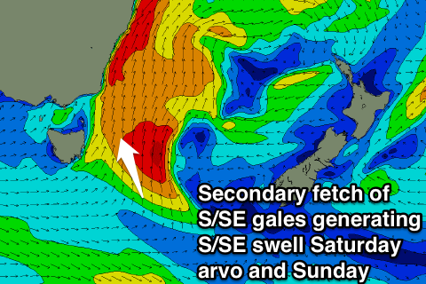 Today's close-range S'ly swell should back off overnight but not as much as expected on Wednesday. This will be because as the low generating the swell moves up the East Coast a secondary fetch of S/SE gales on the tail of the system should generate a reinforcing S/SE groundswell for the upper half of the East Coast tomorrow afternoon. Further south the fetch will be moving out of the swell window.
This should fill in through the day and offer 3-4ft waves across open beaches with larger 5ft sets at south swell magnets. Winds look a little less than ideal though and fresh but easing from the SW.
Come Sunday the S/SE swell should back off from 2-3ft at open beaches with the possibility of the odd bigger set at exposed spots. Winds should be straighter offshore from the West during the morning before swinging more SW into the afternoon.
Come Monday there isn't expected to be any size left at all with tiny wave due that will persist into most of next week.
There's nothing significant on the cards in the longer term, therefore try and work around the S/SE swell due over the weekend. Have a great weekend!