Active period, improving conditions through next week

Eastern Tasmania Forecast by Craig Brokensha (issued Friday 4th July)
Best Days: Early Saturday, Monday and Tuesday in protected northern corners, Wednesday onwards
Recap
Yesterday saw small clean leftover S'ly swell across the coast, while today a new inconsistent SE groundswell filled in. Northern corners faired best with a generally N/NW breeze.
This weekend onwards (Jul 5 onwards)
There should still be the odd hint of SE swell around tomorrow morning, coming in at 1-2ft across open beaches, but get in early as a morning N/NW'ly will give into a freshening E'ly.
Now, the E'ly swell due to develop through Sunday and hold into early next week has been upgraded since Wednesday with the broad surface trough producing the swell in the Southern Tasman Sea now expected to be a touch stronger and broader.
From tomorrow evening, a broad fetch of strengthening E'ly winds are expected to be aimed through our eastern swell window, reaching a peak in intensity through Sunday (just under the gale-force range).
This should kick up an initial short-range E'ly swell later Sunday to 3-4ft+ with a peak in more drawn out E'ly swell due through Monday to 3-5ft or so.
Winds on Sunday will be poor as the trough sits over the coast with fresh to strong E/SE winds, but come Monday the trough will drift south and with this we should see winds tend variable across the northern half of the East Coast and stronger from the N/NE further south. This won't create perfect conditions but there should be some workable options in northern corners.
With the trough drifting south, a drop in swell is due into Tuesday but over towards New Zealand, a fresh fetch of E/NE gales are forecast to develop through Monday.
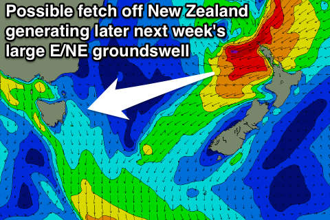 From here on the models diverge quite considerably, with the American solution swinging the fetch more NE and away from our swell window as the fetch continues to strengthen. The European model however has the fetch strengthening while remaining aimed at us, generating a much larger E/NE groundswell for the East Coast.
I feel that we'll see the European solution come off and with this we can expect an initial pulse of E/NE groundswell for Wednesday to be followed up by a larger pulse on Thursday afternoon and Friday morning.
Size wise we're probably looking at a peak in the 4-6ft range, but there's plenty of room for movement, so check back here on Monday for a much clearer idea on the outlook for the second half of next week. Have a great weekend!
Comments
Craig.... Dunno about the "bar graph" for tues/wed and thurs'......
In what regards? Probably won't drop below 3ft or so in between swells if that's what you're looking at.
Yeah, and dont you reckon the second swell will have a touch of north in it? When you highlight on the bar graph, it says east swell...... More like ene or even perhaps ne?
It'll be E/NE, well just north of east but def not north-east. Models have 81deg.
You can see the fetch on this earthnull projection and see it's pretty well straight east with a touch of north.