No swell until at least Sunday afternoon

Eastern Tasmania Forecast by Craig Brokensha (issued Wednesday 25th June)
Best Days: Monday morning
Recap
Tuesday was great with a mix of easing NE windswell and SE groundswell to 2-3ft across open beaches under offshore winds. The swell backed off through the day though and only tiny 0.5ft waves were left into today.
This week and weekend onwards (Jun 26 onwards)
There's no real swell due across the state until at least later Sunday as a series of vigorous but zonal cold fronts push across us. The models are picking up pulses of size but the W/NW and NW direction are tell tale signs that we won't get any size at all.
Into Sunday though a vigorous mid-latitude low pushing across us should kick up a solid increase in S'ly swell later in the day as a fetch of S/SW gales are projected up past the coast (right).
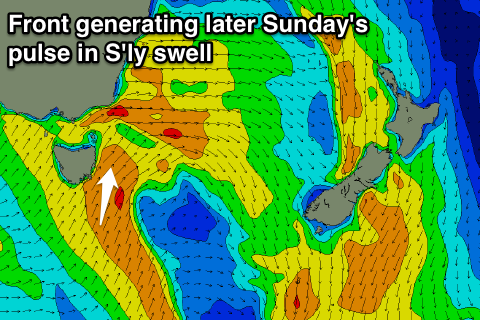 Unfortunately the short-lived nature of the fetch will limit the size and longevity of this swell, with south facing beaches expected to pulse to 3-4ft later in the day before dropping rapidly from 2-3ft Monday morning.
Winds will be a little average as the swell kicks and from the S/SW, but Monday morning will be good for south swell magnets with an early W/NW breeze.
We may see some better S'ly swell for Tuesday as a secondary polar front pushes up more favourably from the south but we'll review this again on Friday.