Fun S'ly swell Thursday, better S/SE groundswell Saturday

Eastern Tasmania Forecast by Craig Brokensha (issued Monday 16th June)
Best Days: Thursday, Saturday
Recap
Saturday started out excellent with Friday's pulse of groundswell hanging in the 3-5ft range with morning offshores. A southerly change limited the best waves to protected spots into the afternoon and Sunday was poor before some new windswell developed.
Today the low responsible for yesterday's building S/SE windswell moved away and conditions improved with a clean 2-3ft of SE swell.
This swell should of eased off this afternoon and there's nothing really major on the cards until the weekend, but read on.
This week (Jun 16 - 20)
The next noticeable increase in swell is due from the S'th on Thursday and this will be generated by a healthy polar low pushing up from below us and towards New Zealand on Wednesday.
The size from this system isn't expected to be too much, but south swell magnets are likely to see 2ft+ sets under persistent NW winds. A drop in size is then due overnight with Friday not expected to offer much at all.
This weekend onwards (Jun 21 onwards)
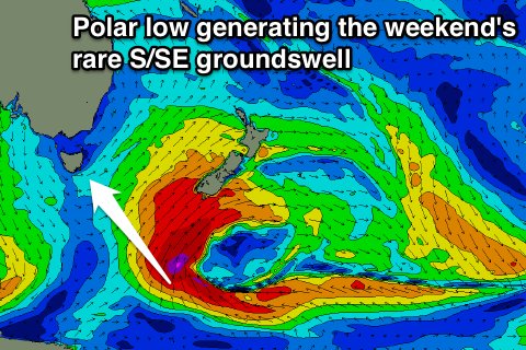 A polar low forming at the base of the front pushing up towards New Zealand is forecast to aim a fetch of severe-gale SE winds towards us. This should generate a good but inconsistent S/SE groundswell for Saturday coming in at 3ft+ across exposed beaches with all day W/NW winds. Sunday will see the swell dropping from 2ft or so, therefore plan a surf around Saturday.
Longer term there's nothing too significant on the cards but we'll review this again Wednesday.