Fun waves Wednesday/Thursday; larger pulse Friday

Eastern Tasmania Forecast by Craig Brokensha (issued Monday 9th June)
Best Days: Wednesday afternoon, Thursday, Friday, Saturday morning
Recap
Saturday was near flat and clean early before a S'ly change moved through. Sunday started off poor but a quick increase in S/SE windswell was seen to 4ft at exposed spots, but conditions were below par with a fresh S'ly wind.
Today was the day to surf, as expected, with the swell easing out of the SE from 2-3ft at open beaches under light morning offshores.
This week (Jun 9 – 13)
As discussed on Friday there's not too much due tomorrow across the coast, but it won't go flat, with today's SE swell due to be replaced with a long-range and inconsistent E/NE trade-swell ahead of some slightly better E/SE swell.
The E/SE swell is being generated by a healthy fetch of strong SE winds off the southern tip of New Zealand's South Island and should fill in Wednesday and peak through the afternoon to 2-3ft across open beaches under fresh NW winds.
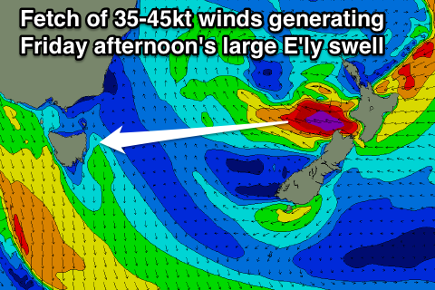 A slight drop is due Thursday from 2ft+ or so, but heading into Friday, a large and strong E'ly groundswell should fill in. The size of this swell has been upgraded slightly with the deep and powerful low pressure system forming over New Zealand responsible for the swell, forecast to be a touch stronger.
During Tuesday and Wednesday we'll see a fetch of gale to severe-gale E'ly winds projected towards us, setting in motion a strong E'ly groundswell.
The swell should arrive through the morning Friday and pulse strongly to 4-6ft at exposed locations. Winds are looking pretty good with a light offshore W/NW'ly ahead of light and variable sea breezes likely from the SE.
Next weekend onwards (Jun 14 onwards)
Saturday should still provide solid waves across the coast but we'll be on the downside of the swell event, with open beaches due to ease from 3-5ft. Winds should be workable and offshore from the SW early before freshening from the S/SE.
Moving into Sunday and a deepening low in the Tasman Sea is expected to bring with it fresh S/SE tending S/SW winds and a spike in S'ly swell, but it won't be until Monday that conditions will clean up. We may see 2ft of leftover swell, but we'll review this Wednesday.