Large swell to end the week and start the weekend

Bali and Mentawais forecast by Craig Brokensha (issued Thursday 23rd August)
Best Days: Every day over the coming period besides Thursday
This week and next (Aug 22 – 31)
Bali: Some new swell should have provided a slight kick in energy across the region today, but we look ahead to the larger and more powerful long-period S/SW groundswell due tomorrow.
This swell filled in across WA yesterday with large surf coming in as expected, and we should see the same swell arriving tomorrow morning, building very strongly into the afternoon.
South facing swell magnets are expected to reach 8ft+ by dark, peaking overnight and easing from the 8ft range on Saturday morning, smaller into Sunday.
Our reinforcing S/SW groundswell for Monday is still on track, generated by a great elongated fetch of pre-frontal W/NW gales moving through the southern Indian Ocean the last few days.
 The swell is due to arrive later Sunday and peak through Monday to 6ft across magnets, easing slowly through Tuesday and Wednesday.
Wave heights will continue to ease into Thursday ahead of a new long-period S/SW groundswell on Friday
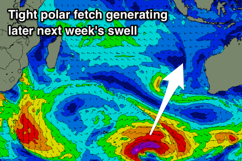
This groundswell will be generated by a strong polar low developing later in our swell window, just east of Heard Island, with a tight fetch of severe-gale W/SW-SW winds forecast to be aimed towards us.
The swell will be quite south in nature, building later Thursday and peaking Friday in the 6ft range, easing Saturday.
We may see a reinforcing mid-period S'ly swell into the weekend, but the models are divergent on the trough/storm moving in through our swell window, linked to this swell.
Coming back to the local winds due through the period and moderate to fresh E/SE trades will persist, a little weaker over the weekend and variable for a period early each morning.
16 day Bali Forecast Graph
16 day East Java Forecast Graph
16 day Sumbawa Forecast Graph
Ments: Firstly looking to the winds, which the models were fighting over even regarding today on Tuesday, and GFS has won the day with NW winds across the region as a small low sits south-west of us.
Depending on where you are located over the coming days you'll see either SW winds (northern Ments) or NE tending E/SE winds (southern Ments) tomorrow, with winds likely to redevelop from the NW across the whole region through Saturday afternoon/Sunday, more variable and out of the E/SE from Monday onwards.
Swell wise, our new kick in swell yesterday and today should be superseded by a larger long-period S/SW groundswell tomorrow, reaching an easy 8ft on the sets across south swell magnets before easing later in the day and down from 6ft+ Saturday morning.
The reinforcing S/SW groundswell looks to offer a boost in energy Monday to 5ft+ or so on the sets before trailing off slowly through the week. Longer term the southerly swells for Bali will be generated too late in our swell window and there's no major size expected at all until maybe next weekend. More on this Tuesday.
16 day Mentawai forecast graph
16 day Nias forecast graph
16 day South Sumatra forecast graph
Comments
Rise in swell on Bukit this morn by looks...Craig whats the Kilojoule rating :-]
Ha.
Been a great Indo season...makes a mockery of the East Coast