Great waves over the coming days, slower next week

Bali and Mentawais forecast by Craig Brokensha (issued Tuesday 14th August)
Best Days: Tomorrow afternoon through Tuesday next week
This week and next (Aug 15 - 24)
Bali: The swell's currently on the way out with a low point due this evening.
From tomorrow though we'll see our good new long-period SW groundswell filling in, generated by a strong mid-latitude low that developed south-east of Madagascar and South Africa last week, pushing east while generating a fetch of severe-gale W/SW winds, with core winds reaching storm-force.
The swell should build steadily through tomorrow, reaching an easy 6ft by dark, most likely 6ft+ and peaking Thursday to 6-8ft across swell magnets.
 A slow drop in size is then due on Friday from 6ft+, smaller into Saturday and reaching a temporary low point early Sunday.
Into Sunday afternoon a new mix of long-range and inconsistent background SW groundswell and better S/SW groundswell are due, peaking Monday.
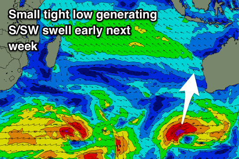
The better S/SW groundswell is currently being generated by a polar front that's developed east of Heard Island, with a tight but slow moving fetch of severe-gale W/SW winds due tomorrow south-west of WA, projecting slightly north-east into Thursday morning before moving out of our swell window.
This swell is due to peak Monday morning to 6ft+ across south swell magnets, with Sunday afternoon's increase only likely yo be 4-6ft by dark.
Following this the swell is expected to fade into the middle of next week ahead of some new long-period groundswell energy later week, but we'll look at this closer on Thursday.
Winds will be moderate to fresh out of the E/SE over the coming period, lighter and variable each morning with local land breezes.
16 day Bali Forecast Graph
16 day East Java Forecast Graph
16 day Sumbawa Forecast Graph
Ments: We've got fresh and gusty SE winds developing across the region and the new long-period SW groundswell should be starting to show on dark across the islands.
This swell is due to peak through tomorrow with 6-8ft sets across swell magnets, easing back slowly from 6ft+ Thursday, smaller Friday and Saturday.
Our models are incorrectly combining some weak S/SE windswell with the easing groundswell and showing a spike in size on Friday, but this won't happen.
The S/SW groundswell for Bali Monday will hardly impact us, with it being generated late in our southern swell window, though some inconsistent background S/SW groundswell is likely to build Saturday, reaching 3-5ft late and peaking Sunday to 4-5ft or so, with the models incorrectly combining swells again.
Easing surf should be seen into the middle of the week ahead of some fun new SW groundswells which we'll look into more on Thursday.
Winds look to persist out of the SE through early next week, possibly relaxing and becoming more variable mid-late week, but we'll confirm this on Thursday.
16 day Mentawai forecast graph
16 day Nias forecast graph
16 day South Sumatra forecast graph