Easing surf, with a good run of large swell from mid-next week

Bali and Mentawais forecast by Craig Brokensha (issued Tuesday 5th September)
Best Days: Wednesday through Friday, later Tuesday onwards
This week and next (Sep 1 - 8)
Bali: Some great new large S/SW groundswell filled in through yesterday, remaining large into this morning but we should be seeing a downwards trend into this afternoon.
The swell should continue to ease back into tomorrow morning from the 6ft on the sets across exposed breaks, but later in the day a new long-period S/SW groundswell is due.
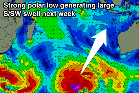
This swell was generated by a late forming but strong polar fetch of gale to severe-gale SW winds projected towards southern Australia over the weekend.
We should see sets reaching over 6ft later in the day as the swell builds, with a peak overnight, easing back from 6ft+ on Thursday. Due to the southerly direction of the swell and where it was generated, the further east you go from Bali, the less size you'll see (more so than normal).
 From here on the swell will fade away, with no major surf due until mid-next week.
Looking at the winds, and moderate to fresh E/SE trades are expected over the coming period, with more variable breezes early each morning.
Coming back to next week, and we're looking at a great period of surf with large back to back groundswells due from mid-week through until the following week owing to a strong node of the Long Wave Trough intensifying across the southern Indian Ocean.
What we'll see is a progression of vigorous storms through our swell window from later this week through at least mid-next week.
Various pulses of S/SW groundswell are due which look to be in the 6-8ft range at this stage, but we'll have a closer look at this Thursday.
16 day Bali Forecast Graph
16 day East Java Forecast Graph
16 day Sumbawa Forecast Graph
Ments: We saw a good pulse of S'ly groundswell through yesterday, with solid sets holding into this morning, but similar to Bali, we'll see the surf ease back over the coming days.
 The swell generated late in Bali's swell window should just impact our southern islands, with exposed breaks continuing in the 4-5ft range through later tomorrow and Thursday morning before fading into the weekend.
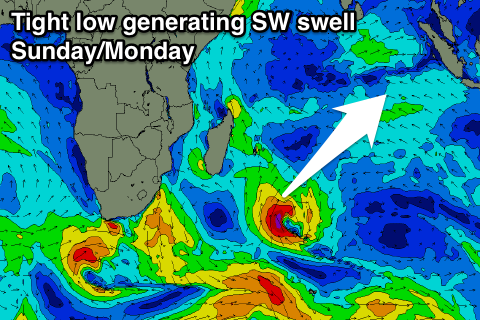
Before next week's run of S/SW groundswell energy, we'll see a good sized SW groundswell across the region Sunday and Monday, generated by a small intense low sitting south-east of Madagascar. This low is generating a slow moving and tight fetch of severe-gale S/SW winds on the edge of our south-western swell window, with a fun SW groundswell due to build Sunday, reaching 4-6ft later in the day and ease from a similar size Monday.
The S/SW groundswell energy is then due from Tuesday with similar sized 6-8ft surf on the cards, but more on this Thursday.
16 day Mentawai forecast graph
16 day Nias forecast graph
16 day South Sumatra forecast graph
Comments
Hey Craig , where's the Thursday Forecast ???
I'm heading to G Land tomorrow and was hoping to use it to help choose which boards to take.
Ran out of time yesterday, had a few. Swells for next week look fun, mostly in the 6ft range on the sets from Wednesday, a touch stronger Friday and then larger Sunday in the 8ft range.
https://www.swellnet.com/reports/indonesia/java/east-java/forecast
Fun looking run in a week there
Over Greedy Bali surf guides taking there kooky learner surfers to all heavy reef breaks
Just Dangerous as !!!!
Update today?