Large consistent S/SW swell to end the week

Bali and Mentawais forecast by Craig Brokensha (issued Tuesday 6th September)
Best Days: Every day over the coming period Bali, out of the north wind in the Ments the next couple of days, everywhere from Friday
This week and next (Sep 7 - 16)
Bali: The surf has been excellent the last few days with large pulses of SW groundswell, the strongest kicking later Sunday and easing off slowly through yesterday.
Today the swell has continued to ease back slowly, but a new reinforcing S/SW groundswell is due to kick later today, peaking tomorrow morning. The source of this swell was a less than favourably aligned by broad and elongated fetch of pre-frontal severe-gale W/NW winds to the south-west of WA.
Exposed breaks should offer 6ft to nearly 8ft sets early, easing back through the afternoon and further Thursday from 5-6ft at magnets.
 A low point in swell activity is due early Friday morning ahead of a large consistent increase in S/SW swell through the day, followed by a secondary pulse Saturday.
This swell started to be generated yesterday by a vigorous polar front projecting north-east towards Bali while generating a broad fetch of SW gales.
The fetch strength wasn't overly spectacular, but the projection up high into the Indian Ocean will help produce a large consistent S/SW groundswell.
Exposed breaks are due to build to 8-10ft by dark Friday across Bali, holding 8-10ft Saturday morning due to a reinforcing S/SW swell from a secondary fetch of SW gales projecting towards us on the tail of the main front.
The swell should start to slowly ease through the afternoon and further from 8ft+ Sunday morning.
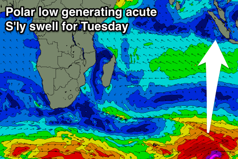
Monday morning will see the swell continuing to ease, but later in the day another large strong pulse of long-period S/SW groundswell is due.
This one will be noticeably less consistent and more south in direction, generated between Heard Island and the South West of WA by a polar low. A fetch of severe-gale to storm-force W/SW winds should generate a good swell, kicking to 6-8ft later in the day, then easing from 6-8ft with maybe the odd bigger one early Tuesday.
A steady drop in size is due through the afternoon and further into the end of the week with no significant follow up swells.
Moderate to fresh E/SE trades tomorrow are expected to increase a little Thursday, before easing back into Friday and further over the weekend, becoming quite weak. A slight increase in the trades is then expected again early next week, tending more variable into the following weekend.
16 day Bali Forecast Graph
16 day East Java Forecast Graph
16 day Sumbawa Forecast Graph
Ments: Easing surf is expected across the Ments from the last few days of large surf, steadying tomorrow to 3-5ft across exposed spots as N/NW winds freshen. A slight kick in new S/SW swell is due Thursday as N'ly winds persist, coming in at 4-5ft+ or so.
 Of greater importance is the large S/SW groundswell due Friday afternoon across the region. The front generating this swell formed east and in our southern swell window, with exposed breaks to the south due to kick to the 6-8ft+ range by dark Friday, easing back from a similar size Saturday morning. Magnets on the south island are likely to see 10ft cleanups at the peak of the swell.
It's worth pointing out that our models are over-forecasting the sizes of these S/SW swell as it incorrectly combines a few different swell trains.
A steady easing trend is then due into Sunday and Monday with the reinforcing long-period groundswell seen across Bali later Monday coming in at an inconsistent 5-6ft+ Tuesday morning before fading into the rest of the week.
Winds will tend more variable from Friday and remain so through most of next week.
Longer term there's nothing too significant on the cards, but more on this Thursday.
16 day Mentawai forecast graph
16 day Nias forecast graph
16 day South Sumatra forecast graph