Fun SW swell from later Saturday, larger short-lived S/SW swell Tuesday

Java, Bali, Lombok, Sumbawa forecast by Craig Brokensha (issued Thursday 10th September)
Best Days: Saturday afternoon onwards
This week and next week (Sep 11 - 18)
Good levels of S/SW swell will continue to ease through this afternoon and bottom out tomorrow morning to an inconsistent 3-5ft across exposed breaks with moderate to fresh E/SE trades (variable early).
Into Saturday our new consistent SW groundswell is due to fill in, building later in the day to 6ft+ across exposed breaks on dark, holding a similar size through Sunday and Monday morning.
The trades should weaken from Sunday and remain so through most of next week, kicking up again from later Thursday. This will allow for variable breezes to last longer through the mornings opening up exposed breaks for a longer period of time.
 Monday's late kick in large S/SW groundswell is still on track but the size has been downgraded a touch.
This is a result of the vigorous polar frontal system projecting a capture fetch towards the Bali region being a touch smaller in scope than forecast on Tuesday.
Still, a fetch of severe-gale to storm-force S/SW winds will be projected perfectly up towards us today and tomorrow before weakening off the WA coast Friday evening.
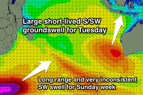
A large but short-lived S/SW groundswell will result, kicking later Monday to the 6-8ft range and peaking early Tuesday to 8ft to occasionally 10ft at exposed breaks, dropping back quickly to 6-8ft into the afternoon. Note our forecast graph is over-forecasting the swell due to it combining a mid-period and the new long-period S/SW groundswell.
A further steady drop is then due Wednesday from 6ft+, back down further from 4-6ft Thursday morning.
Longer term a very inconsistent long-range SW groundswell is due around next Sunday, generated by a vigorous polar frontal system firing up under South Africa through tomorrow and the weekend.
Due to the large distance between the source of the swell and our coasts, there'll be very long waits between sets, with the swell due to peak Sunday to 6ft+ across exposed breaks, easing back slowly through Monday. A secondary more consistent S/SW groundswell is on the cards for Wednesday, but we'll look at this again Tuesday.
16 day Bali Forecast Graph
16 day East Java Forecast Graph
16 day Sumbawa Forecast Graph
Comments
Great satellite pass of the initial stages of the fetch projecting north-east towards WA.
Some 55kt barbs in there..