Large swells on the horizon

Java, Bali, Lombok, Sumbawa forecast by Craig Brokensha (issued Tuesday 18th August)
Best Days: Exposed spots over the coming days, Monday onwards for more swell, large swell into the end of next week
This week and next week (Aug 19 - 28)
Small surf this morning, with some new inconsistent SW groundswell due this afternoon but to no major size. Exposed spots are likely to offer 3ft to possibly 5ft sets before backing off into tomorrow.
A slightly stronger swell is due Thursday to the 4-5ft range and fresh E/SE trades are due to ease from tomorrow, with variable winds lasting longer each morning up until early next week.
A drop in swell is due into Friday, with small inconsistent waves over the weekend.
Into next week, our new long-range and inconsistent SW groundswell is still on track. A vigorous polar low formed south of South Africa a couple of days ago and aimed a slow moving fetch of severe-gale W/SW winds towards us. This system is now weakening just west of Heard Island, leaving a very inconsistent but strong long-period SW groundswell in its wake.
This swell should show later in the day Sunday and then peak through Monday to an inconsistent 5-6ft across exposed breaks, with the chance of the rare bigger bomb.
 A slow drop in size is then due into Tuesday and Wednesday, slowed by a smaller reinforcing S/SW swell.
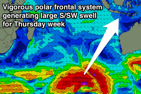
Now, as touched on the last couple of updates, some stronger groundswell energy is finally due into the end of the month and start of September with a series of vigorous polar frontal systems due to fire up through the Indian Ocean from this Friday through the following week and beyond.
An initial strengthening polar frontal system south-east of South Africa this Friday will project a fetch of gale to severe-gale W/SW winds through our southern swell window while tracking towards Australia.
A large long-period S/SW groundswell should be generated, filling in Thursday and peaking through the afternoon/evening to 8-10ft across exposed breaks. This swell will then ease into Friday, with a smaller reinforcing S/SW swell for the weekend, building later Saturday and peaking Sunday afternoon to the 6-8ft range across exposed breaks.
Behind this we may see a similar sized large S/SW groundswell to Thursday's filling in Tuesday/Wednesday the 1st/2nd of September but we'll confirm this on Thursday.
16 day Bali Forecast Graph
16 day East Java Forecast Graph
16 day Sumbawa Forecast Graph
Comments
Hopefully all September delivers!
I'll be heading back from G-Land as one of these bigger swells is due to hit (that's ok coz it will probably be too big for me on the main part of the point).
My question to put out there: has anyone travelled back from there by boat through a biggish swell - ie. 10ft or above?
What was it like crossing the reef out to the boat - dangerous? Gear getting washed out of the boat?
And what was the trip back like? It's normally pretty rugged, battling and crashing into the SE trade swell, but did the large SW swell make it worse? I'm wondering if it's not going to be making it worse because SW swell will be coming more from astern?
It's fine mate
No dramas
Fun
Went across and back last year on solid swell Speedies was 10 to 12ft was a bit rock and roll at times haha.May 17 2007 when you still had to go through the river mouth at the village was complete madness Gland was 20ft at the time.Did see a great righthander though spinning off for ever.
Hey Craig, 2 days ago (on the 17th), the long-term forecast for Tue 1 Sept was calling for 12-15ft, but in the latest run it's totally disappeared!
Any ideas what happened to it?
Fell off the back of your desk maybe?
Or maybe you got a wad of notes in a brown paper bag to hush it up? (just joking)
Yeah the models have been all over the place regarding the swell potential into the end of the month and start of September.
When this is the case, put less confidence in the long term forecast until it starts firming up on the outlook.
Unfortunately the system forecast to generate Thursday's swell has weakened significantly and we're probably only looking at 6-8ft now.
System generating the swell for the start of Sept goes berko south-east of South Africa but then weakens very quickly. This will also limit size and consistency from this storm as well.
Will continue to update as we get more data.
Ooooh Craig this swell is lining up with the arrival of cyclone Gary and he's looking to CHARGE. Can't wait to throw myself at a few sticky situations on the island of dreams. Can't wait to go surfing either.
On the advice of a fellow hard-charging hard-man from the SN forums I've got my outer island gun ready to go, can't wait to show the island what the Thunder from Down Under can bring. Incoming!
That would be ol Kezza.......fucking legend......only bloke I know who posts on trip adviser when searching his family tree ??? serious !
Many of Gary's decisions are made following the credo: What would Kerry do?
A man after my own heart. Hard Charging, Ripped, Modest.
Just remember Udo, a journey of a thousand burpees starts with a single pushup.
Not sure if this is the right place but as we're about to be slammed by the swell of the year this weekend (no doubt I'll be watching safely from shore) I just want to say SN have been absolutely spot-on with their forecasts for my part of the world.
Great job guys.
Awesome Zen!
Yeah Super Typhoon Atsani is a doozey!
WAMs show it perfectly!
https://www.swellnet.com/reports/japan/honshu/chiba-east/forecast
https://www.swellnet.com/reports/japan/honshu/chiba-east/forecast
That North Korean super bank might be worth a run also!