Small until a fun swell Tuesday/Wednesday

Java, Bali, Lombok, Sumbawa forecast by Craig Brokensha (issued 26th Mar)
Best Days: Every day over the coming period besides Monday when the swell bottoms out
This week and weekend (Mar 27 - 29)
After a strong pulse of S/SW groundswell earlier in the week we've been on a downwards trend in size and this is set to continue through tomorrow and into the weekend. Only a slight and very inconsistent pulse of new S/SW groundswell is due overnight Saturday and into Sunday morning.
Exposed breaks will be the go with variable winds each morning and light E/SE trades into the afternoons.
 Next week onwards (Mar 30 onwards)
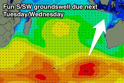
A low point in swell activity is due Monday but as we head into Tuesday and Wednesday, a good moderate sized S/SW groundswell is due across the islands.
This is being generated to the south-west of WA by a couple of vigorous polar frontal systems which are mainly aiming their energy south of Australia.
Still we should see moderate amounts of S/SW groundswell spreading radially up towards us from this source, building through Tuesday and reaching an inconsistent 4-5ft at exposed breaks into the afternoon with 4-6ft sets Wednesday morning. A slow drop is then due into the afternoon and further Thursday, steadying Friday.
A very long-period swell showing on the charts will have no considerable size attached to it, with it being generated in our far swell window south of South Africa.
With this in mind wave heights will continue to drop away into the following weekend with light variable winds each morning and afternoon sea breezes.
Longer term there's nothing major showing into the following week, but there may be some better activity from mid-April.
16 day Bali Forecast Graph
16 day East Java Forecast Graph
16 day Sumbawa Forecast Graph